Images
August 16, 2023 - Sahara Dust Travels across the Atlantic
Tweet
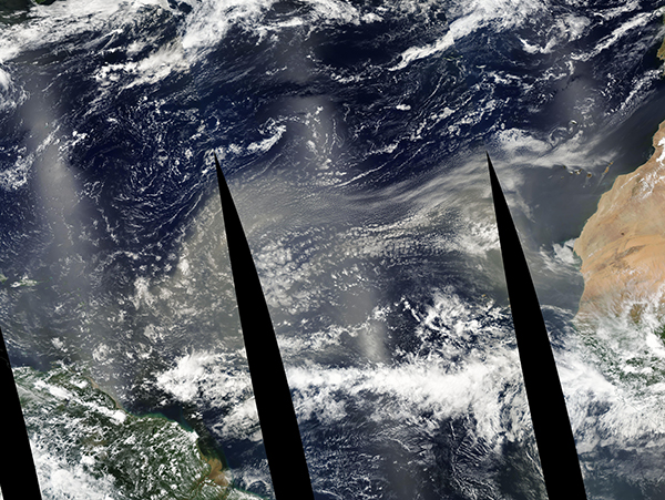
In mid-August 2023, a river of dust from the Sahara Desert stretched across the Atlantic Ocean, clouding skies over several Caribbean islands. On August 15, a local weather station in Trinidad and Tobago reported “Thick dust haze blankets the region due to significant Saharan dust”. The near-term forecast is for gusty winds and thunderstorms as a result of a tropical wave, along with continued dust over the Lesser Antilles for the next several days. The dust is suppressing tropical storm development, but may bring hazardous air quality as the cloud moves westward.
The Moderate Resolution Imaging Spectroradiometer (MODIS) on NASA’s Aqua satellite captured a long and broad blanket of dust leaving Africa and extending all the way to the Caribbean on August 14. This true-color image is a mosaic, which means several swaths of MODIS data, each acquired as the satellite orbits the Earth, have been stitched together to create one long image. Black areas occur along the edge of the swaths, where MODIS did not acquire data.
The Sahara Desert is one of the major sources of airborne dust in the world. At times—most frequently in mid-June through mid-August—the dust takes a ride across the Atlantic Ocean on the Saharan Air Layer (SAL). The SAL is a mass of very dry, dusty air that forms over the Sahara Desert and flows across the Atlantic as often as every 3-5 days during peak season, carrying dust as far as South America, Central America and sometimes reaches U.S. states, especially Texas and Florida.
Image Facts
Satellite:
Aqua
Date Acquired: 8/14/2023
Resolutions:
1km (15.9 MB),
Bands Used: 1,4,3
Image Credit:
MODIS Land Rapid Response Team, NASA GSFC


