Images
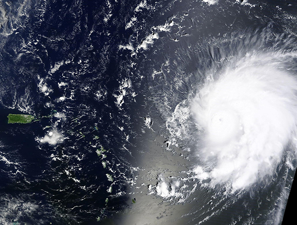
September 10, 2023 - Powerful Hurricane Lee over the Atlantic Ocean
Tweet
At 5:00 a.m. EDT on September 7, Hurricane Lee was a Category 1 hurricane spinning over the Atlantic Ocean carrying maximum sustained winds near 80 mph (130 km/h). Twenty-four hours later Lee had undergone rapid intensification and was roaring monster of a Category 5 hurricane with maximum sustained winds of 165 mph (270 km/h). While rapid intensification is defined as an increase in maximum sustained winds of a tropical cyclone by at least 35 mph (56 km/h) in a 24-hour period, Hurricane Lee had increased wind speed by a whopping 85 mph (137 km/h) between September 7 and September 8.
The Moderate Resolution Imaging Spectroradiometer (MODIS) on NASA’s Terra satellite acquired a true-color image of Hurricane Lee on September 8 shortly after it attained Category 5 strength. At that time the storm sported a small cloud-filled eye along with a tight apostrophe-shape that is typical of strong cyclones. However, the storm’s asymmetry showed that Lee was battling wind shear on its western side as it continued to move in that direction.
By late in the evening on September 8, wind shear had taken a toll on the hurricane. According to the National Hurricane Center (NHC) Lee’s maximum sustained winds had dropped to 115 mph (185 km/h)—Category 3—as it continued to push to the west-northwest across the Atlantic. The struggle continued through September 9. By 11:00 p.m. EDT, Lee’s maximum wind speeds had dropped to 105 mph (165 km/h), or a strong Category 2. At that time, it was located about 285 miles (445 km) northeast of the Northern Leeward Islands.
Hurricane Lee’s time as a Category 2 hurricane is expected to be short. The NHC forecasts strengthening is expected on September 10 as conditions become more favorable. It is expected to quickly reach Major hurricane status (Category 3 or higher) and stay a Major hurricane through at least September 13. Near the end of that time, interaction with a strong steering system should slow Lee’s forward motion and turn it’s direction of travel to north-northwest. However, the NHC advised that it is too soon to know what level of impacts, if any, Lee might have along the US East Coast, Atlantic Canada, or Bermuda late next week. They urge readers to monitor updates to the forecast for Lee over the next several days.
Image Facts
Satellite:
Terra
Date Acquired: 9/8/2023
Resolutions:
1km (571.5 KB), 500m (1.9 MB),
Bands Used: 1,4,3
Image Credit:
MODIS Land Rapid Response Team, NASA GSFC


