
Images


November 6, 2023 - Fires in Arizona
 Tweet
Tweet
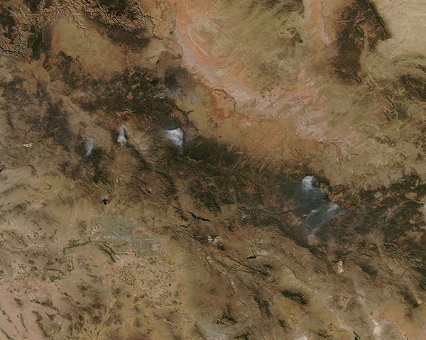
On November 2, 2023, the Moderate Resolution Imaging Spectroradiometer (MODIS) on NASA’s Aqua satellite acquired a true-color image showing several fires in the mountains across Arizona. Each red “hot spot” marks an area where the thermal bands on the instrument detected high temperatures. When combined with typical smoke, as in this image, such hot spots are diagnostic for actively burning fire.
The fires in this image are likely a mix of prescribed burns and wildfire. In late October, two wildfires were sparked by lightning in remote acreage of the Apache-Sitgreaves National Forests, which is the approximate location of the fires visible in the east. The two fires were the Fish Creek Fire and the KP Fire. According to the Arizona Emergency Information Network, as of the afternoon of November 1 the Fish Creek Fire was burning on 105 acres about 32 miles southwest of Alpine. The KP fire was located about 33 miles southwest of Alpine and was 25 acres in size.
Most of the other fires are likely prescribed burns, which are fires deliberately set to manage land or forests. On November 2, the Arizona Emergency Information Network advised that fire crews would continue with ignitions on the Mud Springs prescribed fire, which was planned to encompass 1,829 acres in the Apache-Sitgreaves National Forest near Vernon. Several other prescribed fires were in progress or planned across the state, including near Flagstaff and Sedona, both located near the western fires captured in this image.
Prescribed fires are an effective tool for restoring fire-dependent ecosystems and reducing the risk of high-severity wildfires. Fire managers use prescribed fire to improve forest health, remove hazardous fuels, increase firefighter safety, enhance wildlife habitat, and protect communities and watersheds.
Image Facts
Satellite:
Aqua
Date Acquired: 11/2/2023
Resolutions:
1km (47.4 KB), 500m (657.7 KB), 250m (657.7 KB)
Bands Used: 1,4,3
Image Credit:
MODIS Land Rapid Response Team, NASA GSFC
