Images
January 14, 2024 - Snow on Japan's Honshu Island
Tweet
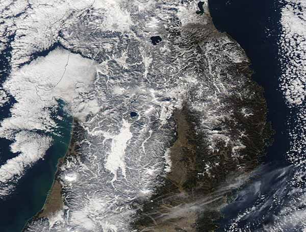
On January 11, 2024, cloudy skies opened over northern Honshu Island, Japan, to reveal a scene painted winter-white. The Moderate Resolution Imaging Spectroradiometer (MODIS) on NASA’s Aqua satellite captured a true-color image of the often-cloud-covered region on that same day.
In the image, widespread snow stretched across almost all of the visible landscape, especially in the north and west. A small green section in the southeast remains nearly snow-free. A bright area south of Lake Tazawa, Akita Prefecture, appears to be the location of heaviest accumulation.
For many people, thoughts of Japan conjure up images of cherry blossoms and sunny weather. However, the country is no stranger to snow, thanks its location east of the frigid blasts from the Siberian region of Russia. Indeed, Japan is a snowy powerhouse. An article published by Weather Underground, “Thanks to “ocean effect” (also called “sea effect”) snow and mountains reaching 10,000 feet, hundreds of inches of powder are dumped along the northwest side of Japan every winter. It is estimated that up to 1,500 inches falls in the highest terrain, making it arguably the snowiest place on Earth.”
“Sea effect” or “ocean effect” snow is much like the more familiar “lake effect” snow. Heavy snow is created when extremely cold, dry air passes over relatively warm water. As the moisture evaporates, it rises to form clouds filled with moisture. As winds carry the clouds over land, precipitation begins – and in cold weather, that means snow – and usually a lot of it. In the case of Japan, Russia’s Siberian air masses provide the frigid air, the Sea of Japan (East Sea) provides the moisture, and the islands capture the snowy precipitation.
Image Facts
Satellite:
Aqua
Date Acquired: 1/11/2024
Resolutions:
1km (48.8 KB), 500m (92.2 KB), 250m (263.5 KB)
Bands Used: 1,4,3
Image Credit:
MODIS Land Rapid Response Team, NASA GSFC


