Images
February 14, 2024 - Snow Across the Southwest
Tweet
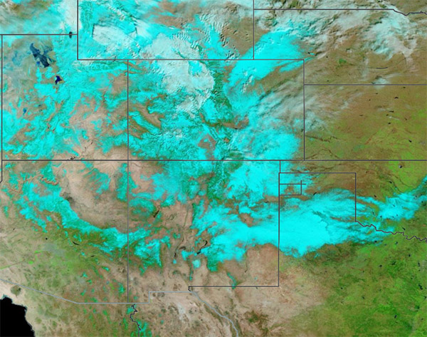
The newest in a series of winter storms dropped heavy snow across the Southwestern United States from February 9-11, 2024. This storm began as an atmospheric river over the Pacific Ocean before drenching California in early February, triggering flooding and landslides in low-lying areas and heavy snow in the mountains. By February 7, it was moving slowly eastward and taking aim at the Southwest. Ultimately, the system also brought intense snow to parts of the Great Plains before blanketing parts of the Mid-Atlantic and New England on February 13.
The Moderate Resolution Imaging Spectroradiometer (MODIS) on NASA’s Terra satellite acquired a false-color image of snow atop high elevations across the Southwest on February 12. In this type of image, visible light and infrared light are used to help distinguish snow, which appears bright electric blue, from cloud, which looks white. Some very cold, high clouds may be lightly tinted blue. In addition, vegetation looks green, open water appears dark blue, and open land is tan.
The image is centered on the Rocky Mountains of Colorado. According to the Denver Post, snow totals in Colorado for the 24 hours between February 9-10 included 13.5 inches (34.3 cm) at Black Forest, 10.8 inches (27.4 cm) at Genesee, and 9.1 inches (23.1 cm) at Wheat Ridge. The city of Colorado Springs received 4.3 inches (10.9 cm) of fresh snow, while Denver International Airport reported more than 3.7 inches (9.4 cm).
Image Facts
Satellite:
Terra
Date Acquired: 2/12/2024
Resolutions:
1km (623.6 KB), 500m (2.2 MB), 250m (6.8 MB)
Bands Used: 7,2,1
Image Credit:
MODIS Land Rapid Response Team, NASA GSFC


