
Images


November 14, 2024 - Extreme Rapid Intensification for Super Typhoon Usagi
 Tweet
Tweet
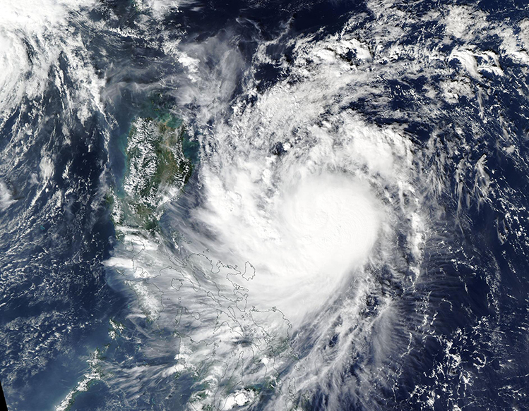
Meteorologists at the Joint Typhoon Warning Center (JTWC) typically are a pretty stoic bunch and, having seen nearly everything in the way of storm systems, they are not prone to exclamations. However, the behavior of Super Typhoon Usagi prompted a remarkable discussion by the JTWC in mid-November 2024.
“Well, that escalated quickly…” was the first sentence in the JTWC discussion published at 10:00 a.m. EST (1500 UTC) on November 13. They then explained that Usagi “just put on an amazing show of extremely rapid intensification (ERI), increasing approximately 40 knots in just six hours.” That’s 46 miles per hour or 74 km/h. Rapid intensification is defined by the National Hurricane Center as an increase in the maximum sustained winds of a tropical cyclone of at least 30 knots (34.5 mph or 55.5 km/h) in a 24-hour period.
At the time of the discussion, maximum sustained winds were estimated at 115 knots (132 mph or 212.4 km/h). That is equivalent to a Category 4 hurricane on the Saffir Simpson Hurricane Wind Scale. Super Typhoon Usagi was located about 193 miles (310 km) south of Aparri, Philippines and was tracking west-northwestward at that time. Six hours later, at 3:00 p.m. EDT (2100 UTC) the JTWC noted that maximum sustained winds had increased to about 150 mph (242 km/h) which is a strong Category 4 storm.
Super Typhoon Usagi is expected to clip the northern tip of Luzon Island, Philippines early on November 14 and may retain its current devastating strength. It then is expected to meet increasingly unfavorable conditions which should turn it north and then northeastward, bringing it very close to the coast of Taiwan by November 15 as a weakening typhoon.
The Moderate Resolution Imaging Spectroradiometer (MODIS) on NASA’s Aqua satellite acquired a true-color image of Super Typhoon Usagi on the morning of November 13. Convective bands are tightly wrapped around a nearly fully cloud-filled eye as the storm tracks towards the Philippines. The large island of Luzon can be seen to the storm’s west while outer convective bands are bringing rain and wind to the southern islands.
Image Facts
Satellite:
Aqua
Date Acquired: 11/13/2024
Resolutions:
1km (593.9 KB), 500m (6.9 MB), 250m (5 MB)
Bands Used: 1,4,3
Image Credit:
MODIS Land Rapid Response Team, NASA GSFC
