
Images


January 8, 2025 - Frigid Temperatures and Deep Snow in the Midwestern United States
 Tweet
Tweet
In the first week of January 2025, a potent winter storm not only delivered heavy snow and damaging ice to the central and eastern United States, it also dropped temperatures to bone-chilling levels. An initial burst of cold air arrived in the north-central U.S. at the start of the month and then expanded to embrace the south and east. By January 6, frigid air had spread across most of the country.
The coldest temperatures enveloped several states in a swath starting with North Dakota and Minnesota in the north, where temperatures at about 2 meters (6.5 feet) above the ground reached as low as -22°F (-30°C), according to data from the Goddard Earth Observing System (GEOS) model.
Air temperatures were warmer at ground level, but still remarkably frigid. In Wichita, Kansas, the National Weather Service reported daytime highs in the mid-teens (Fahrenheit) on January 6. Farther north in Grand Forks, North Dakota, the temperature that day barely reached above the single digits. As far south as northern Texas and as far east as the the Mid-Atlantic, temperatures were 5°F to 20°F below average, according to news reports.
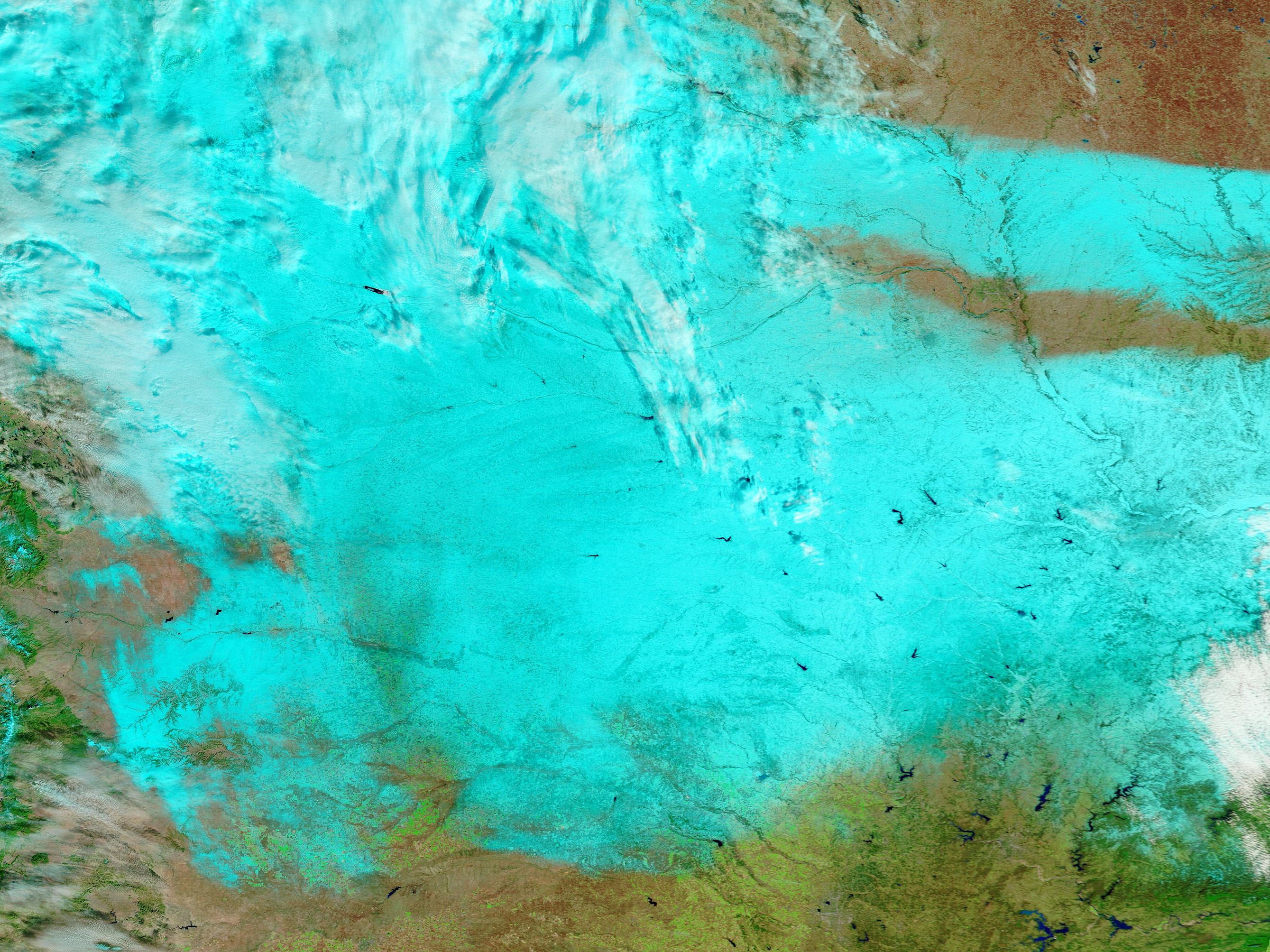
The early January chill accompanied a potent storm system that dumped snow and ice on states from the Plains to the Mid-Atlantic. The Moderate Resolution Imaging Spectroradiometer (MODIS) on NASA’s Terra satellite acquired this false-color image that shows a band of fresh snow across several Midwest states, including Kansas (south), Nebraska, and South Dakota (north). In this type of image, snow appears bright blue, cloud looks white, and vegetation shows up as green.
On January 5, Chapman, Kansas, north of Wichita, received 18 inches (46 centimeters) of snow—the largest amount measured in the state, according to local news reports. Kansas City International Airport recorded 11 inches (28 centimeters) that day. As the storm moved east, it continued to snarl traffic and led to the cancellation of hundreds of flights.
As people dug out from the most recent storm, forecasters watched another system that could bring more winter weather to the U.S. South and up to the East Coast by the end of the week.
Image Facts
Satellite:
Terra
Date Acquired: 1/6/2025
Resolutions:
1km (715.9 KB), 500m (1.9 MB), 250m (2.6 MB)
Bands Used: 7,2,1
Image Credit:
MODIS Land Rapid Response Team, NASA GSFC
In the first week of January 2025, a potent winter storm not only delivered heavy snow and damaging ice to the central and eastern United States, it also dropped temperatures to bone-chilling levels. An initial burst of cold air arrived in the north-central U.S. at the start of the month and then expanded to embrace the south and east. By January 6, frigid air had spread across most of the country.
The coldest temperatures enveloped several states in a swath starting with North Dakota and Minnesota in the north, where temperatures at about 2 meters (6.5 feet) above the ground reached as low as -22°F (-30°C), according to data from the Goddard Earth Observing System (GEOS) model.
Air temperatures were warmer at ground level, but still remarkably frigid. In Wichita, Kansas, the National Weather Service reported daytime highs in the mid-teens (Fahrenheit) on January 6. Farther north in Grand Forks, North Dakota, the temperature that day barely reached above the single digits. As far south as northern Texas and as far east as the the Mid-Atlantic, temperatures were 5°F to 20°F below average, according to news reports.
The early January chill accompanied a potent storm system that dumped snow and ice on states from the Plains to the Mid-Atlantic. The Moderate Resolution Imaging Spectroradiometer (MODIS) on NASA’s Terra satellite acquired this false-color image that shows a band of fresh snow across several Midwest states, including Kansas (south), Nebraska, and South Dakota (north). In this type of image, snow appears bright blue, cloud looks white, and vegetation shows up as green.
On January 5, Chapman, Kansas, north of Wichita, received 18 inches (46 centimeters) of snow—the largest amount measured in the state, according to local news reports. Kansas City International Airport recorded 11 inches (28 centimeters) that day. As the storm moved east, it continued to snarl traffic and led to the cancellation of hundreds of flights.
As people dug out from the most recent storm, forecasters watched another system that could bring more winter weather to the U.S. South and up to the East Coast by the end of the week.
Image Facts
Satellite:
Terra
Date Acquired: 1/6/2025
Resolutions:
1km (715.9 KB), 500m (1.9 MB), 250m (2.6 MB)
Bands Used: 7,2,1
Image Credit:
MODIS Land Rapid Response Team, NASA GSFC
