
Images


January 31, 2025 - Snow in the Tennger Desert


January 28, 2025
January 16, 2025
Tweet
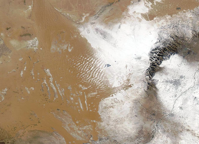
A passing winter storm dropped a layer of white atop an expanse of tan sand and dust in Inner Mongolia in mid-January 2025.
The Moderate Resolution Imaging Spectroradiometer (MODIS) on NASA’s Aqua satellite acquired this true-color image of a coating of snow on the eastern Tengger Desert on January 28. To compare the extent of the fresh snow with a view of the region on a more typical winter day, click on the dates to reveal a second Aqua MODIS image of the same area acquired on January 16. In the earlier image, snow only dusts the flanks and feet of the Helan Mountains, while on January 28 much of the desert is coated in white. Snow also outlines the tan crescents of the large shifting sand dunes that are a notable feature of this desert. Strips of white that remain the same in both images are salt pans, indicative of the very dry nature of the region.
The Tengger Desert is the fourth largest desert in China, covering a total area of about 36,700 square kilometers (14,170 square miles), an area slightly larger than the U.S. state of Maryland. It stretches across central Gansu Province, the northern Ningxia Hui Autonomous Region, and the southwestern Alxa Left Banner of the Inner Mongolia Autonomous Region. Although the intensely arid desert receives very little rain, precipitation in the form of light snow can be expected at least a few times each winter.
Image Facts
Satellite:
Aqua
Date Acquired: 1/28/2025
Resolutions:
1km (60.7 KB), 500m (144.9 KB), 250m (242.5 KB)
Bands Used: 1,4,3
Image Credit:
MODIS Land Rapid Response Team, NASA GSFC
January 28, 2025 January 16, 2025
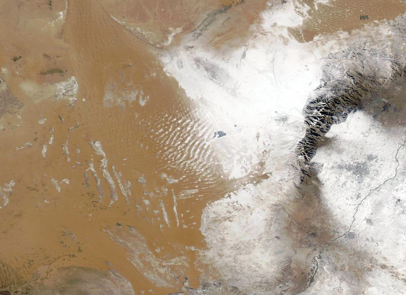
A passing winter storm dropped a layer of white atop an expanse of tan sand and dust in Inner Mongolia in mid-January 2025.
The Moderate Resolution Imaging Spectroradiometer (MODIS) on NASA’s Aqua satellite acquired this true-color image of a coating of snow on the eastern Tengger Desert on January 28. To compare the extent of the fresh snow with a view of the region on a more typical winter day, click on the dates to reveal a second Aqua MODIS image of the same area acquired on January 16. In the earlier image, snow only dusts the flanks and feet of the Helan Mountains, while on January 28 much of the desert is coated in white. Snow also outlines the tan crescents of the large shifting sand dunes that are a notable feature of this desert. Strips of white that remain the same in both images are salt pans, indicative of the very dry nature of the region.
The Tengger Desert is the fourth largest desert in China, covering a total area of about 36,700 square kilometers (14,170 square miles), an area slightly larger than the U.S. state of Maryland. It stretches across central Gansu Province, the northern Ningxia Hui Autonomous Region, and the southwestern Alxa Left Banner of the Inner Mongolia Autonomous Region. Although the intensely arid desert receives very little rain, precipitation in the form of light snow can be expected at least a few times each winter.
Image Facts
Satellite:
Aqua
Date Acquired: 1/28/2025
Resolutions:
1km (60.7 KB), 500m (144.9 KB), 250m (242.5 KB)
Bands Used: 1,4,3
Image Credit:
MODIS Land Rapid Response Team, NASA GSFC
