
Images


February 15, 2025 - Atmospheric River Strikes Southern California
 Tweet
Tweet
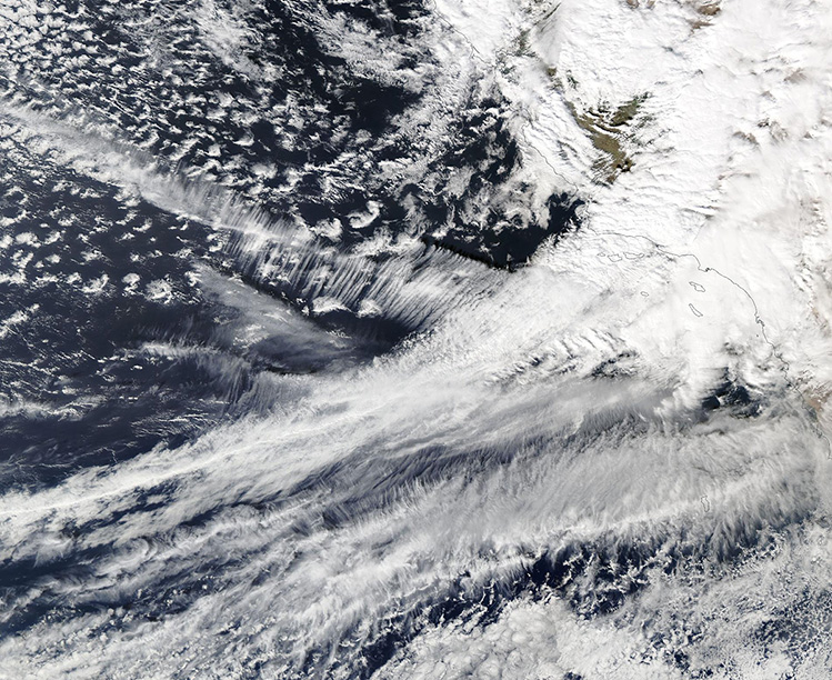
A precipitation-filled atmospheric river struck southern California in mid-February 2025, kicking off the fifth coast-to-coast storm to strike the United States since the start of the new year. Heavy rain drenched much of the region on February 12-14, including areas recently ravaged by wildfires. Local media reported that on February 13 one highway intersection near Pacific Palisades was buried under at least 3 feet (1 meter) of sludge. It was also reported that a road near the Eaton Fire burn scar (near Altadena, California) was covered in “several feet of mud, vegetation and trees” despite a concrete block wall designed to prevent debris flows. Several media outlets showed several cars mired in mud flows.
In the mountains, the precipitation is in the form of heavy snow. Mammoth Mountain, In the Sierra Nevada mountains, posted on Instagram on February 14 that it received about 6 feet (72 inches/183 cm) in the previous 36 hours. They also noted that two of its ski patrol staff were caught in an avalanche on that same morning. The resort’s website notes that risk of avalanche is “extreme,” and the slopes will be closed on February 15.
This strong system is expected to continue to disrupt conditions across the United States as it plows forward, crossing the Rocky Mountains, the Plains, the Great Lakes States, and eventually the Northeast over the upcoming weekend.
On February 13, the Moderate Resolution Imaging Spectroradiometer (MODIS) on NASA’s Aqua satellite acquired this true-color image of the long atmospheric river arching northeastward over the Pacific Ocean to strike the southwestern coast of the United States. The city of Los Angeles, California, is buried under the thickest area of cloud.
Image Facts
Satellite:
Aqua
Date Acquired: 2/13/2025
Resolutions:
1km (617 KB), 500m (1.9 MB), 250m (5.3 MB)
Bands Used: 1,4,3
Image Credit:
MODIS Land Rapid Response Team, NASA GSFC
