
Images


March 1, 2025 - Tropical Cyclone Garance
 Tweet
Tweet
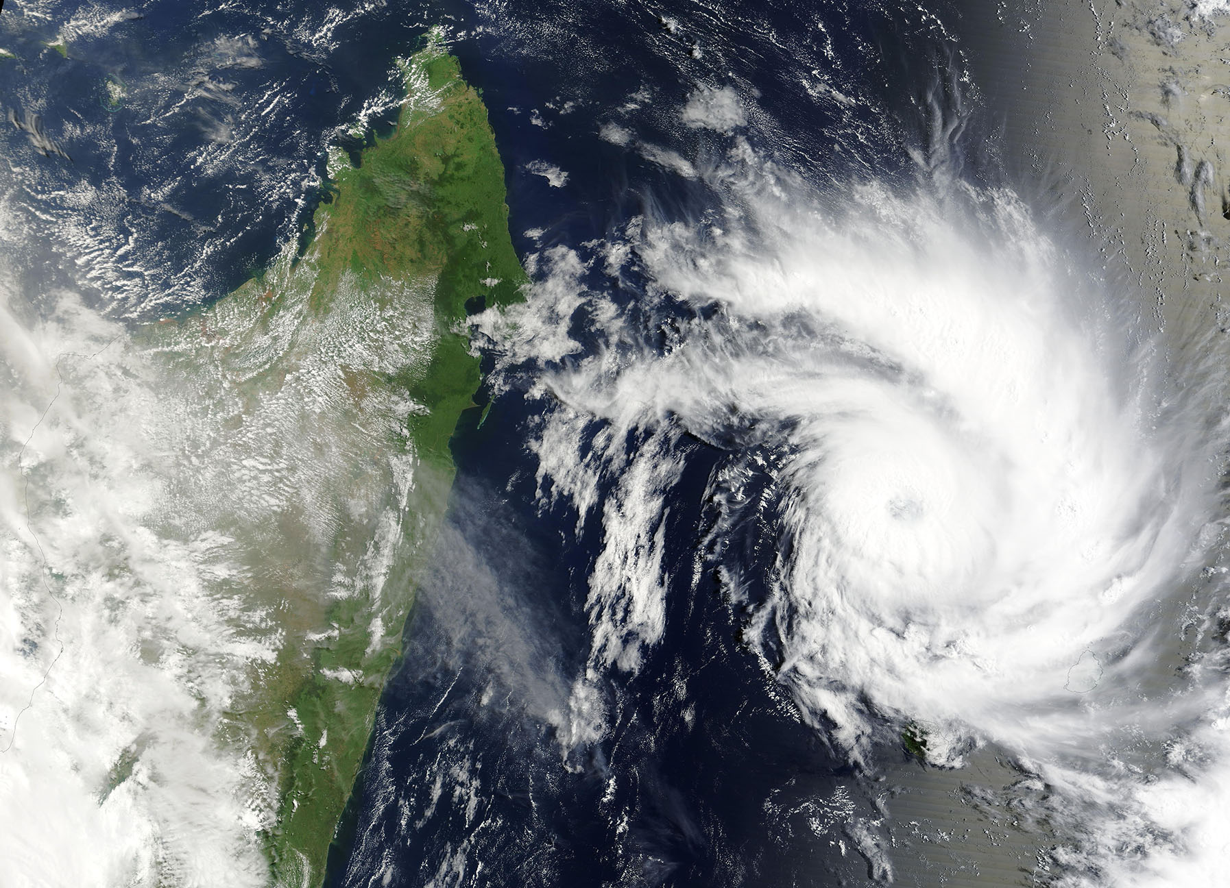
Tropical Cyclone Garance first formed over the southern Indian Ocean just east of northern Madagascar on February 25, 2025. It reached peak strength on February 27 with maximum sustained winds of 120 miles per hour (193 km/h), which is the equivalent of a Category 3 storm on the Saffir-Simpson Hurricane Wind Scale.
Garance had weakened slightly, carrying maximum sustained winds of about 105 miles per hour (169 km/h), when it made landfall on the island of Réunion on February 28. The Associated Press reported that the storm brought heavy rains and flooding to the island, accompanied by power outages and damage to buildings. Three people have been reported to have died in the storm on Réunion.
The Moderate Resolution Imaging Spectroradiometer (MODIS) on NASA’s Aqua satellite acquired this true-color image of Tropical Cyclone Garance on February 27, when it was at near-peak strength. The storm was moving southward towards Réunion, at the time this image was captured. Réunion, a French overseas department, is located just off the lower right corner of the image.
On February 28, the Joint Typhoon Warning Center (JTWC) forecasted that Tropical Cyclone Garance will continue to track southward. It is moving into an unfavorable environment, with high wind shear and cooling sea surface temperatures. The JTWC advised that the storm’s maximum sustained winds should drop to about 52 miles per hour (83.6 km/h) by the evening of March 1.
Image Facts
Satellite:
Terra
Date Acquired: 2/27/2025
Resolutions:
1km (558.6 KB), 500m (1.7 MB), 250m (3.7 MB)
Bands Used: 1,4,3
Image Credit:
MODIS Land Rapid Response Team, NASA GSFC
Tropical Cyclone Garance first formed over the southern Indian Ocean just east of northern Madagascar on February 25, 2025. It reached peak strength on February 27 with maximum sustained winds of 120 miles per hour (193 km/h), which is the equivalent of a Category 3 storm on the Saffir-Simpson Hurricane Wind Scale.
Garance had weakened slightly, carrying maximum sustained winds of about 105 miles per hour (169 km/h), when it made landfall on the island of Réunion on February 28. The Associated Press reported that the storm brought heavy rains and flooding to the island, accompanied by power outages and damage to buildings. Three people have been reported to have died in the storm on Réunion. The Moderate Resolution Imaging Spectroradiometer (MODIS) on NASA’s Aqua satellite acquired this true-color image of Tropical Cyclone Garance on February 27, when it was at near-peak strength. The storm was moving southward towards Réunion, at the time this image was captured. Réunion, a French overseas department, is located just off the lower right corner of the image.
On February 28, the Joint Typhoon Warning Center (JTWC) forecasted that Tropical Cyclone Garance will continue to track southward. It is moving into an unfavorable environment, with high wind shear and cooling sea surface temperatures. The JTWC advised that the storm’s maximum sustained winds should drop to about 52 miles per hour (83.6 km/h) by the evening of March 1.
Image Facts
Satellite:
Terra
Date Acquired: 2/27/2025
Resolutions:
1km (558.6 KB), 500m (1.7 MB), 250m (3.7 MB)
Bands Used: 1,4,3
Image Credit:
MODIS Land Rapid Response Team, NASA GSFC
