
Images


March 9, 2025 - Wet Season at the Makgadikgadi
 Tweet
Tweet
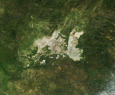
In early March, near the end of the annual rainy season, normally arid northern Botswana becomes a lush with moisture. Vegetation abounds, the savannah greens, and water seeps into one of the largest, driest salt pans on Earth, the Makgadikgadi.
The expanse of tender vegetation, along with the appearance of available water for drinking, draws an amazing array of wildlife during the rainy season. By early March, ungulates, particularly the Burchell’s zebra and blue wildebeest, have migrated en mass to the Makgadikgadi, joining meerkat, flamingo, and many other birds and beasts enjoying the rich feeding grounds. Within a month, however, the rains will subside, the waters will begin to recede, and vegetation will soon wither, triggering a massive exodus of wildlife from what will return to an extremely harsh and dry environment.
The Moderate Resolution Imaging Spectroradiometer (MODIS) acquired this true-color image of the Makgadikgadi salt pans on March 7, 2025, when the dried mineral salts had become moist and were surrounded by vegetation.
The Makgadikgadi salt pans were formed about two million years ago, when part of the Kalahari Desert was home to one of the largest inland seas in the world. With no natural outflow to wash away minerals that were swept into the sea, salts slowly accumulated in the low-lying areas of the lake. About 10,000 years ago, water levels began to dwindle—partly because the lake overflowed into surrounding valleys, partly because of a drier climate. As the lake dried up, several salt pans (areas of dried minerals) were left behind in the arid desert landscape. Today, the Makgadikgadi salt pan spans about 10,000 square miles (30,000 square kilometers), making it roughly the size of Belgium.
Image Facts
Satellite:
Terra
Date Acquired: 3/7/2025
Resolutions:
1km (61.9 KB), 500m (155.7 KB), 250m (308.9 KB)
Bands Used: 1,4,3
Image Credit:
MODIS Land Rapid Response Team, NASA GSFC
