
Images


April 11, 2025 - Wildfires in Ireland and Wales
 Tweet
Tweet
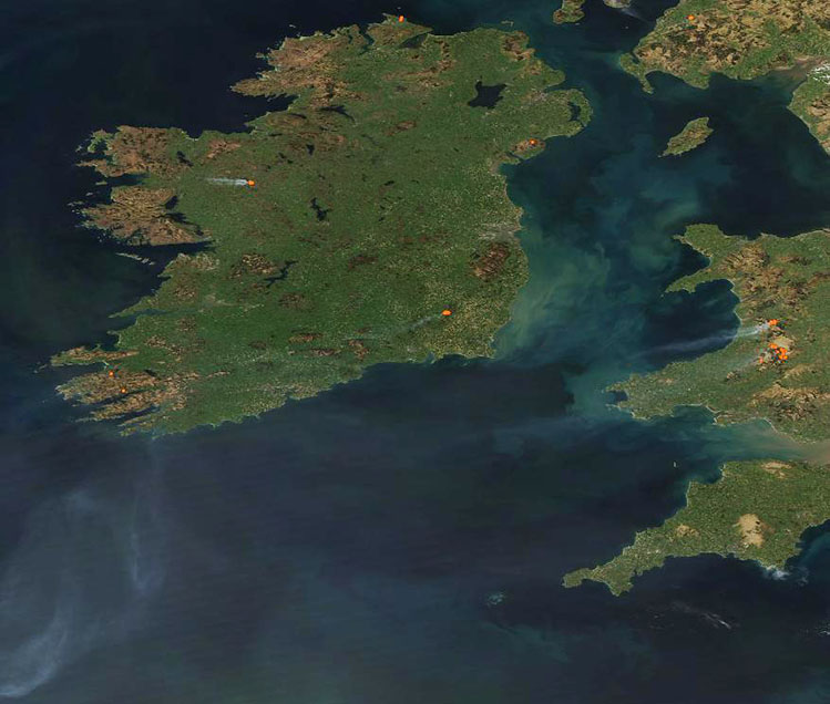
Plumes of smoke from multiple wildfires streak across the skies of the British Isles in this true-color image acquired by the Moderate Resolution Imaging Spectroradiometer (MODIS) on NASA’s Aqua satellite on April 9, 2025.
Each red “hot spot” marks an area where the thermal bands on the MODIS instrument detected high temperatures. When combined with typical smoke, as in this image, such hot spots are diagnostic for actively burning fire. At least 5 large fires can be seen in the country of Ireland, which spans 5/6 of the island of Ireland. One large fire is visible in Northern Ireland, which is part of the United Kingdom and sits in the northeastern region of the island. In the east, clusters of multiple fires in Wales, also part of the United Kingdom, pump smoke across the Irish Sea.
MODIS satellite imagery has captured intermittent wildfire activity across the United Kingdom and Ireland since early March, according to a review of NASA Worldview Images. However, a high-pressure system that brought sunny skies and rising temperatures in early April brought an increase in wildfire activity. The number of large fires appeared to be near-peak across the British Isles on April 9 and included not only the fires seen here, but wildfires in Scotland and England.
On April 11, the Northern Ireland Fire and Rescue Service (NIFRS) wrote that, “From Thursday 3 April – Thursday 10 April, NIFRS received 2,014 emergency calls and attended 1,112 incidents, with 296 of these being wildfire incidents.” On that same day, both Ireland and the United Kingdom posted warnings for fire weather and heat, and media reported notable wildfires across the region, especially in gorse and peatland. Gorse is a low-growing plant that dries quickly when denied water or in warm temperatures. Peat, which is found in moist bogs, also becomes highly flammable when the water in the bogs evaporates.
With temperatures expected to rise to 23°C (73.4°F) in parts of the United Kingdom and 24°C (75.2°F) in Ireland over the next day or two, accompanied by gusting winds and relatively low humidity, the risk of new fire starts and rapid fire growth will remain high over the region in the near-term. Rain is in the forecast for the upcoming weekend, which will hopefully aid firefighting efforts.
Image Facts
Satellite:
Aqua
Date Acquired: 4/9/2025
Resolutions:
1km (56.5 KB), 500m (314 KB), 250m (660.6 KB)
Bands Used: 1,4,3
Image Credit:
MODIS Land Rapid Response Team, NASA GSFC
