
Images


May 6, 2025 - Flooding on the Red River and Lake Texoma
 Tweet
Tweet
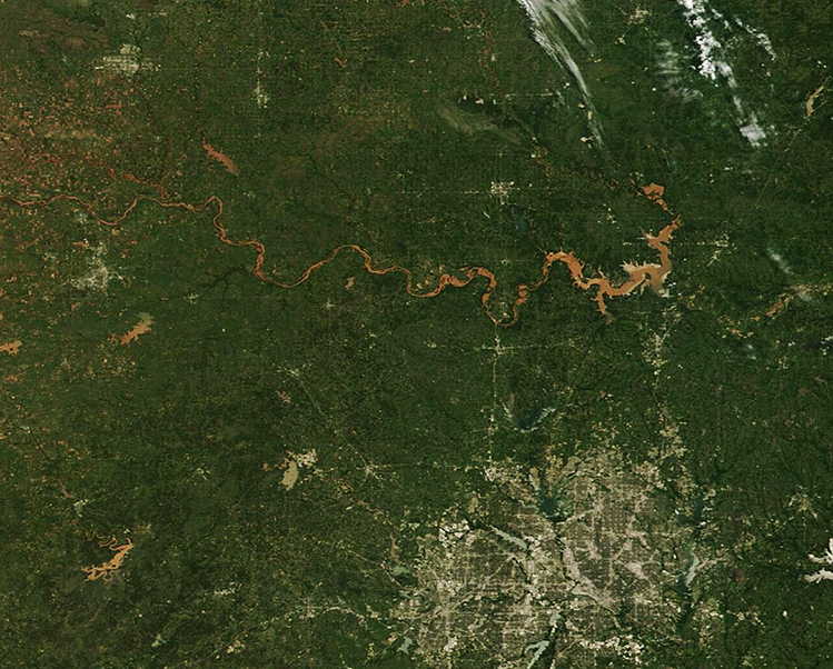
Weeks of intense rain capped off by severe storms lead to widespread flooding in parts of Oklahoma and Texas by early May 2025. According to Oklahoma City’s News 9 team, Oklahoma City recorded 12.5 inches of rain in April, the highest ever for the month and surpassing a 77-year-old record, leading to flash flooding and many water rescues. For example, the Oklahoma City metro area logged 139 flood-related emergency calls in just a few days near the end of April and, in Lawton, 73 citizens were said to have been saved by rescue crews from rapidly rising water.
The damage was so severe that on May 5, the Oklahoma governor declared a disaster emergency for multiple counties in that state.
Northern Texas also reeled under the battering weather, with widespread flooding of cropland, especially wheat, threatening major economic damage for loss of both crops and, potentially, livestock.
The Moderate Resolution Imaging Spectroradiometer (MODIS) on NASA’s Terra satellite acquired this true-color image of widespread flooding of the sediment-laden Red River and Texoma Reservoir on May 4. The large city to the south of the mud-colored waters is the Dallas-Fort Worth, Texas metro area. The Red River delineates the boundary between Oklahoma (north) and Texas (south).
Additional severe weather and more rain is forecast for the region for the next several days. Lake Texoma, shared by Oklahoma and Texas, is forecast to create to 633.70 feet by May 9, which is about seven feet below overflowing the spillway.
Image Facts
Satellite:
Terra
Date Acquired: 5/4/2025
Resolutions:
1km (120 KB), 500m (324.2 KB), 250m (721 KB)
Bands Used: 1,4,3
Image Credit:
MODIS Land Rapid Response Team, NASA GSFC
Weeks of intense rain capped off by severe storms lead to widespread flooding in parts of Oklahoma and Texas by early May 2025. According to Oklahoma City’s News 9 team, Oklahoma City recorded 12.5 inches of rain in April, the highest ever for the month and surpassing a 77-year-old record, leading to flash flooding and many water rescues. For example, the Oklahoma City metro area logged 139 flood-related emergency calls in just a few days near the end of April and, in Lawton, 73 citizens were said to have been saved by rescue crews from rapidly rising water. The damage was so severe that on May 5, the Oklahoma governor declared a disaster emergency for multiple counties in that state.
Northern Texas also reeled under the battering weather, with widespread flooding of cropland, especially wheat, threatening major economic damage for loss of both crops and, potentially, livestock.
The Moderate Resolution Imaging Spectroradiometer (MODIS) on NASA’s Terra satellite acquired this true-color image of widespread flooding of the sediment-laden Red River and Texoma Reservoir on May 4. The large city to the south of the mud-colored waters is the Dallas-Fort Worth, Texas metro area. The Red River delineates the boundary between Oklahoma (north) and Texas (south).
Additional severe weather and more rain is forecast for the region for the next several days. Lake Texoma, shared by Oklahoma and Texas, is forecast to create to 633.70 feet by May 9, which is about seven feet below overflowing the spillway.
Image Facts
Satellite:
Terra
Date Acquired: 5/4/2025
Resolutions:
1km (120 KB), 500m (324.2 KB), 250m (721 KB)
Bands Used: 1,4,3
Image Credit:
MODIS Land Rapid Response Team, NASA GSFC
