
Images


September 15, 2025 - Lake Yamma Yamma Remains Full
 Tweet
Tweet
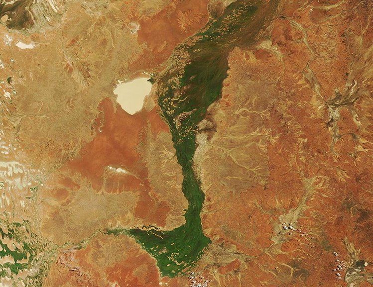
A series of heavy rainfall events drenched Queensland between January and May 2025, filling rivers to overflowing and ultimately sending floodwaters into the normally parched channel country of Australia’s interior. According to the Queensland Reconstruction Authority website, the first round came between January 29 and February 28, when a tropical low inundated North and Far North Queensland. Then, between March 1 and March 16, Tropical Cyclone Alfred battered parts of the state, especially South East Queensland, becoming “one of the most significant weather events in Australia’s recent history”. Finally, between March 21-May 19, a surface trough brought widespread rain and flooding across Western Queensland. By late May, several towns were inundated with the highest floodwaters measured since 1974.
The extensive rain, especially in Western Queensland, sent rising floodwaters into rivers and even pushed extreme flooding into channel country—a normally arid portion of the outback cut by dry braided channels. By mid-March, Cooper Creek (Kinipapa) had filled its large floodplain and water was beginning to reach Lake Yamma Yamma, an ephemeral lake that, most of the time, is no more than a dry depression topped with thick salt crust. Further south along Cooper Creek, water levels peaked at 14.5 meters (a little over 47 feet) near the Innamincka Causeway—the highest level on record.
While the immediate effect of widespread flooding was disastrous, with impassable roads, soaked pastures, damaged homes, submerged crops, drowned livestock, and shuttered natural areas, the long-term effect was more positive. Moisture spurred growth of vegetation in areas normally desert-dry and freshly-filled ephemeral lakes sprang back to life to provide habitat for birds and other wildlife.
This true-color image, acquired by the Moderate Resolution Imaging Spectroradiometer (MODIS) on NASA’s Terra satellite on September 12, shows the lingering effects of southern Queensland’s earlier inundation. Widespread greening along Cooper Creek is obvious and the former desiccated salt pan, Lake Yamma Yamma, appears to be filled with water. The beige color of the lake comes from both minerals and sediment suspended in the water.
According to earlier MODIS images, water first appeared to arrive in Yamma Yamma by late February, with little more arriving in March, when several days of thick cloud cover obscured the lake from view. When clouds cleared on April 3, Cooper Creek was in severe flood stage and Lake Yamma Yamma was completely filled. Satellite imagery also shows that by late April, most of the floodwater around Cooper Creek had receded and, in its place, green vegetation had begun to color the landscape. By September 12, substantial greening remained in the Cooper Creek floodplain and Lake Yamma Yamma remained very well-filled with water.
Image Facts
Satellite:
Terra
Date Acquired: 9/12/2025
Resolutions:
1km (168.1 KB), 500m (480 KB), 250m (980.8 KB)
Bands Used: 1,4,3
Image Credit:
MODIS Land Rapid Response Team, NASA GSFC
