
Images


November 20, 2025 - Tropical Cyclone Fina
 Tweet
Tweet
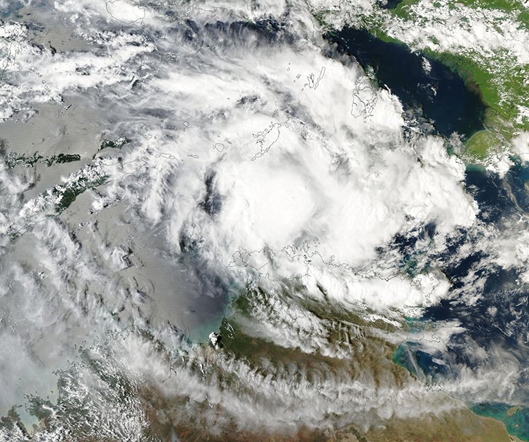
Tropical Cyclone Fina filled the Timor and Arafura Seas on November 19, 2025, when the Moderate Resolution Imaging Spectroradiometer (MODIS) on NASA’s Aqua satellite acquired this true-color image of the storm.
Near this time, the center of the storm was located about 170 kilometers (105 miles) south of Crocker Island and 400 km (250 miles) northeast of the coastal city of Darwin. Maximum sustained winds were about 95 kilometers per hour (56 mph) near the center and gusts of up to 130 km/h (80 mph), according to the Australian Bureau of Meteorology (BOM).
As can be seen in the image, the broad center of Fina stretched from near the southern coast of Yamdena Island, Indonesia to the tip of Melville and Bathurst Island, Northern Territory, Australia. Convective bands stretched much further, bringing rain and wind across coastal Northern Territory and much of eastern Indonesia. Skies were mostly clear over the island of New Guinea, in the northeast.
Fina formed between the Timor and Arafura Seas on November 18 and began tracking eastward. By February 19, it had reached its near maximum eastward travel and was forecast to make a hard southwestward turn and track towards landfall over Australia. Tropical Cyclone Fina is expected to make landfall near Cape Don on the western tip of the Cobourg Peninsula on November 21. It is then expected to pass over Melville Island before skirting the mainland north of the coastal town of Darwin.
The BOM has issued a cyclone watch alert for communities in northwest Arnhem Land and Tiwi Islands. They also advise that Fina will make landfall as a category two storm on the Australian scale. The Australian Tropical Cyclone Intensity Scale measures the strength of a cyclone by maximum wind gusts and is useful for any cyclone at gale strength or higher. A category two cyclone would have wind gusts between 125 and 169 km/h (78-99 mph) and a central pressure between 971 and 985 hPa.
Image Facts
Satellite:
Aqua
Date Acquired: 11/19/2025
Resolutions:
1km (542.8 KB), 500m (1.6 MB), 250m (4.4 MB)
Bands Used: 1,4,3
Image Credit:
MODIS Land Rapid Response Team, NASA GSFC
