

Images


November 25, 2025 - Ogaden Desert
 Tweet
Tweet
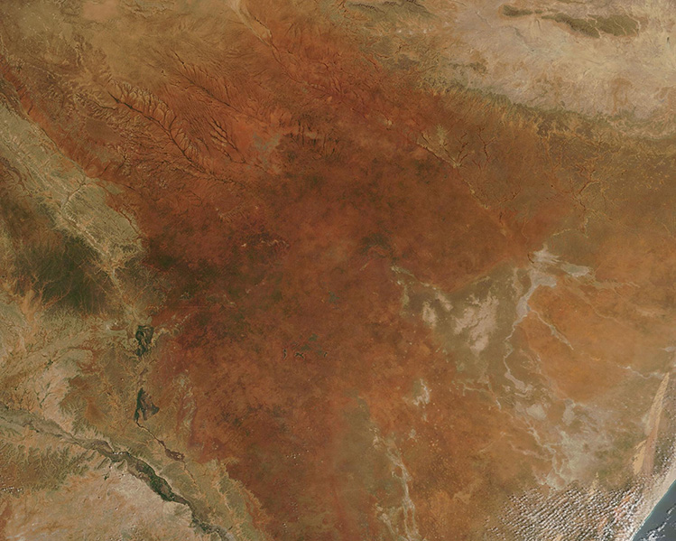
On November 19, 2025, the Moderate Resolution Imaging Spectroradiometer on NASA’s Terra satellite acquired this true-color image centered on the bright orange region known as the Ogaden Desert.
The very arid Ogaden region sprawls across a barren, dry plain primarily in Ethiopia. It extends from near the Somalia-Ethiopia border in the east to the Ethiopian Highlands in the west. The Shebelle River cuts through the region, flowing from the Ethiopian Highlands and into Somalia. In the southern reaches, the Shebelle becomes seasonal and is dry much of the year. The Ogaden region has been an area of conflict and political instability for many years.
In this image, Ethiopia lies in the west and covers most of the territory visible. Somalia lies in the east and southeast and has a coastline on the Indian Ocean. A bit of the Indian Ocean can be seen in the lower right corner (southeast) and the Shebelle lies in the southwest (lower left).
Image Facts
Satellite:
Terra
Date Acquired: 11/19/2025
Resolutions:
1km (144.3 KB), 500m (421.2 KB), 250m (479.4 KB)
Bands Used: 1,4,3
Image Credit:
MODIS Land Rapid Response Team, NASA GSFC
On November 19, 2025, the Moderate Resolution Imaging Spectroradiometer on NASA’s Terra satellite acquired this true-color image centered on the bright orange region known as the Ogaden Desert.
The very arid Ogaden region sprawls across a barren, dry plain primarily in Ethiopia. It extends from near the Somalia-Ethiopia border in the east to the Ethiopian Highlands in the west. The Shebelle River cuts through the region, flowing from the Ethiopian Highlands and into Somalia. In the southern reaches, the Shebelle becomes seasonal and is dry much of the year. The Ogaden region has been an area of conflict and political instability for many years.
In this image, Ethiopia lies in the west and covers most of the territory visible. Somalia lies in the east and southeast and has a coastline on the Indian Ocean. A bit of the Indian Ocean can be seen in the lower right corner (southeast) and the Shebelle lies in the southwest (lower left).
Image Facts
Satellite:
Terra
Date Acquired: 11/19/2025
Resolutions:
1km (144.3 KB), 500m (421.2 KB), 250m (479.4 KB)
Bands Used: 1,4,3
Image Credit:
MODIS Land Rapid Response Team, NASA GSFC


