
Images


June 18, 2024 - Sediment-stained Bay of Fundy
 Tweet
Tweet
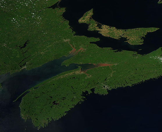
On June 6, 2024, the Moderate Resolution Imaging Spectroradiometer (MODIS) on NASA’s Aqua satellite acquired a true-color image highlighting the spectacular chocolate color waters at the northeastern reach of the Bay of Fundy.
The Bay of Fundy is an inlet of the Atlantic Ocean separating the Canadian provinces of New Brunswick, which lies on the north and west, from Nova Scotia on the south and east side of the Bay. Prince Edward Island, which sits in the Gulf of Saint Lawrence, can also be seen in this image.
The uniquely chocolate-colored rivers that flow into the Bay of Fundy pick up sediment far upstream as they pass through soft, red, and easily eroded Triassic-era sandstone of northeastern Canada. In addition, the Bay’s spectacular tidal action—it has the highest tides observed tides anywhere on Earth—stirs the mudflats at the head of the Bay and adds to the sediment-staining. The height of the tide at the long, narrow Minas Basin can reach 16 meters (53 feet). By comparison, most of the coast of the United States has a tidal range of 1-2 meters (3-6 feet).
Image Facts
Satellite:
Aqua
Date Acquired: 6/16/2024
Resolutions:
1km (63.6 KB), 500m (185.6 KB), 250m (326 KB)
Bands Used: 1,4,3
Image Credit:
MODIS Land Rapid Response Team, NASA GSFC
