
Images


June 23, 2024 - Drought in Southern Africa


June 20, 2024
June 19, 2023
Tweet
Even in good years, Namibia is one of the driest countries in sub-Saharan Africa. Most of the country receives, on average, just 258 millimeters (10 inches) of rain per year, although annual rainfall amounts can vary considerably year-to-year. The Caprivi Strip, in the northeast section of Namibia along the border with Botswana and Zambia gets the highest annual average rainfall—about 650 millimeters (25 inches). The western regions average 50 millimeters (2 inches) or less in an entire year.
But 2024 is not a good year. Rainfall has been so scarce that on May 22, the Namibian President declared a national state of emergency due to the worst drought the country has experienced in 100 years. And Namibia is not alone—much of Southern Africa is also experiencing severe drought. This includes Zambia, Zimbabwe, southeastern Angola, and parts of Botswana.
Damage from the severe drought has been widespread, affecting people, livestock, agriculture, and wildlife. On June 21, the Botswanan President declared the 2023-2024 season an “extreme agricultural drought year”, with conditions in February 2024 the driest since 1980. Media reports that water levels in reservoirs are critically low and major rivers at lowest water levels in at least a decade. Most crops have failed due to the lack of rain, with total output expected to meet only 6 percent of the country’s need. As grasslands have deteriorated, at least 16,000 head of livestock have reportedly died.
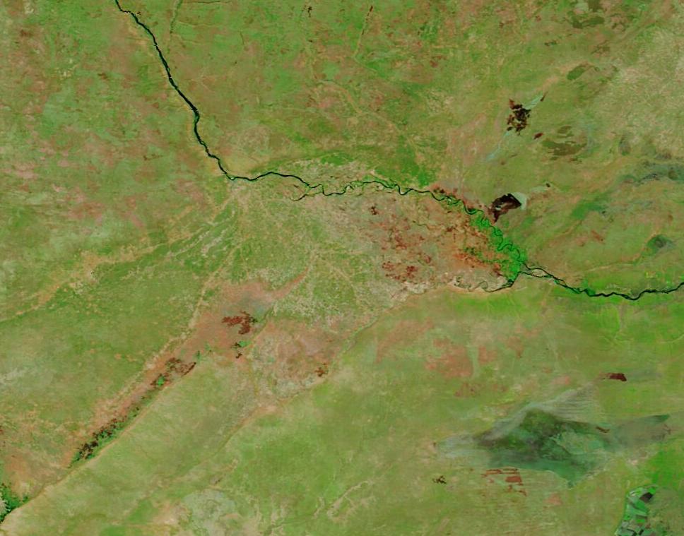
The Moderate Resolution Imaging Spectroradiometer (MODIS) on NASA’s Terra satellite acquired a pair of false-color images centered near the confluence of the Chobe River (south) and the Zambezi River (north). The top image was acquired on June 20, 2024, and the second image, which can be viewed by clicking on the date, was acquired on June 19, 2023.
In this type of false-color image, vegetation looks bright green, water appears blue, open land shows tones of tan and brown, and areas where fire has recently burned looks brick red, black, or orange.
The Chobe River forms the border between Botswana and the Caprivi Strip region of Namibia while the Zambezi River runs along the border of Namibia and Zambia. Although the Caprivi Strip is normally the wettest region in Namibia, on June 20, 2024, it appeared parched, with sparse, patchy vegetation. The presence of numerous orange spots throughout the region, particularly in Namibia, suggests many fires have burned here recently—a common sequela when drought is combined with high air temperatures. The Chobe River is barely visible.
Clicking on the June 19, 2023, image reveals a very different scene. Here, the Namibian floodplain between the Chobe and Zambezi Rivers looks bright green, indicating it is flush with water and vegetation. This area houses the Kasika Conservancy, where elephant, buffalo, crocodile, hippopotamus, antelope, birds, and various fish species flourish. The Chobe River is also quite apparent in this image. Evidence of fire appears on agricultural land surrounding the rivers in all three countries, but not in the Kasika Conservancy land, unlike in 2024.
Image Facts
Satellite:
Terra
Date Acquired: 6/20/2024
Resolutions:
1km (33.8 KB), 500m (68.4 KB), 250m (94.1 KB)
Bands Used: 7,2,1
Image Credit:
MODIS Land Rapid Response Team, NASA GSFC
June 20, 2024 June 19, 2023
Even in good years, Namibia is one of the driest countries in sub-Saharan Africa. Most of the country receives, on average, just 258 millimeters (10 inches) of rain per year, although annual rainfall amounts can vary considerably year-to-year. The Caprivi Strip, in the northeast section of Namibia along the border with Botswana and Zambia gets the highest annual average rainfall—about 650 millimeters (25 inches). The western regions average 50 millimeters (2 inches) or less in an entire year.
But 2024 is not a good year. Rainfall has been so scarce that on May 22, the Namibian President declared a national state of emergency due to the worst drought the country has experienced in 100 years. And Namibia is not alone—much of Southern Africa is also experiencing severe drought. This includes Zambia, Zimbabwe, southeastern Angola, and parts of Botswana.
Damage from the severe drought has been widespread, affecting people, livestock, agriculture, and wildlife. On June 21, the Botswanan President declared the 2023-2024 season an “extreme agricultural drought year”, with conditions in February 2024 the driest since 1980. Media reports that water levels in reservoirs are critically low and major rivers at lowest water levels in at least a decade. Most crops have failed due to the lack of rain, with total output expected to meet only 6 percent of the country’s need. As grasslands have deteriorated, at least 16,000 head of livestock have reportedly died.
The Moderate Resolution Imaging Spectroradiometer (MODIS) on NASA’s Terra satellite acquired a pair of false-color images centered near the confluence of the Chobe River (south) and the Zambezi River (north). The top image was acquired on June 20, 2024, and the second image, which can be viewed by clicking on the date, was acquired on June 19, 2023.
In this type of false-color image, vegetation looks bright green, water appears blue, open land shows tones of tan and brown, and areas where fire has recently burned looks brick red, black, or orange.
The Chobe River forms the border between Botswana and the Caprivi Strip region of Namibia while the Zambezi River runs along the border of Namibia and Zambia. Although the Caprivi Strip is normally the wettest region in Namibia, on June 20, 2024, it appeared parched, with sparse, patchy vegetation. The presence of numerous orange spots throughout the region, particularly in Namibia, suggests many fires have burned here recently—a common sequela when drought is combined with high air temperatures. The Chobe River is barely visible.
Clicking on the June 19, 2023, image reveals a very different scene. Here, the Namibian floodplain between the Chobe and Zambezi Rivers looks bright green, indicating it is flush with water and vegetation. This area houses the Kasika Conservancy, where elephant, buffalo, crocodile, hippopotamus, antelope, birds, and various fish species flourish. The Chobe River is also quite apparent in this image. Evidence of fire appears on agricultural land surrounding the rivers in all three countries, but not in the Kasika Conservancy land, unlike in 2024.
Image Facts
Satellite:
Terra
Date Acquired: 6/20/2024
Resolutions:
1km (33.8 KB), 500m (68.4 KB), 250m (94.1 KB)
Bands Used: 7,2,1
Image Credit:
MODIS Land Rapid Response Team, NASA GSFC
