
Images


July 8, 2024 - Accelerating Melting of the Juneau Ice Field

Original Image
Highlight Juneau Icefield
Tweet
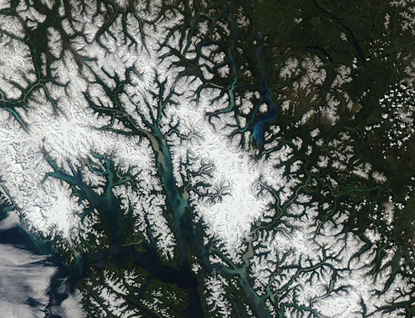
Straddling the Coast Mountains along the Alaska-Canada border, the Juneau Icefield stretches more than 1,500 square miles to capture the title of the fifth-largest icefield in North America. This magnificent, frigid expanse spawns 38 major glaciers, including the well-studied Mendenhall Glacier. The most recent period of neo-glaciation shaped the Juneau Icefield at least 3,000 years ago. Today, however, scientists are expressing concern at its rapid retreat in a warming climate.
In an article published on July 2, 2024, in Nature Communications, Bethan Davies, PhD, from Newcastle University in the United Kingdom, and her team reported that the melting of the Juneau icefield has accelerated and could soon reach an irreversible tipping point.
In an interview published by Newcastle University Press Office, Dr. Davies stated, “Using satellites, photos and old piles of rocks, we were able to measure the ice loss across Juneau Icefield from the end of the last “Little Ice Age” (about 250 years ago) to the present day. We saw that the glaciers began shrinking after that cold period ended in about 1770. This ice loss remained constant until about 1979, when it accelerated. It accelerated again in 2010, doubling the previous rate. Glaciers there shrank five times faster between 2015 and 2019 than from 1979 to 1990.”
Melting is accelerating due to a warming climate, which has triggered a feedback loop in the ice itself. She explains, “Our data shows that as the snow decreases and the summer melt season lengthens, the icefield is darkening. Fresh, white snow is very reflective, and much of that strong solar energy that we experienced in the summer of 2022 is reflected back into space. But the end of summer snowline is rising and is now often occurring right on the plateau of the Juneau Icefield, which means that older snow and glacier ice is being exposed to the sun. These slightly darker surfaces absorb more energy, increasing snow and ice melt.”
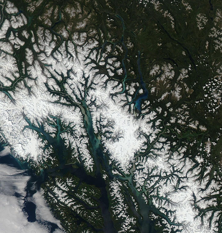
On June 19, 2024, the Moderate Resolution Imaging Spectroradiometer (MODIS) on NASA’s Aqua satellite acquired a true-color image of snow and ice atop the Coast Mountains. Although snow is widespread, only a portion of the image belongs to the heavily glaciated Juneau Icefield. This area can be viewed by clicking on the “Highlight Juneau Icefield” label. Here the boundaries of the Juneau Icefield has been outlined in blue.
Image Facts
Satellite:
Aqua
Date Acquired: 6/19/2024
Resolutions:
1km (100.9 KB), 500m (241.8 KB), 250m (480.3 KB)
Bands Used: 1,4,3
Image Credit:
MODIS Land Rapid Response Team, NASA GSFC
Original Image Highlight Juneau Icefield
Straddling the Coast Mountains along the Alaska-Canada border, the Juneau Icefield stretches more than 1,500 square miles to capture the title of the fifth-largest icefield in North America. This magnificent, frigid expanse spawns 38 major glaciers, including the well-studied Mendenhall Glacier. The most recent period of neo-glaciation shaped the Juneau Icefield at least 3,000 years ago. Today, however, scientists are expressing concern at its rapid retreat in a warming climate.
In an article published on July 2, 2024, in Nature Communications, Bethan Davies, PhD, from Newcastle University in the United Kingdom, and her team reported that the melting of the Juneau icefield has accelerated and could soon reach an irreversible tipping point. In an interview published by Newcastle University Press Office, Dr. Davies stated, “Using satellites, photos and old piles of rocks, we were able to measure the ice loss across Juneau Icefield from the end of the last “Little Ice Age” (about 250 years ago) to the present day. We saw that the glaciers began shrinking after that cold period ended in about 1770. This ice loss remained constant until about 1979, when it accelerated. It accelerated again in 2010, doubling the previous rate. Glaciers there shrank five times faster between 2015 and 2019 than from 1979 to 1990.”
Melting is accelerating due to a warming climate, which has triggered a feedback loop in the ice itself. She explains, “Our data shows that as the snow decreases and the summer melt season lengthens, the icefield is darkening. Fresh, white snow is very reflective, and much of that strong solar energy that we experienced in the summer of 2022 is reflected back into space. But the end of summer snowline is rising and is now often occurring right on the plateau of the Juneau Icefield, which means that older snow and glacier ice is being exposed to the sun. These slightly darker surfaces absorb more energy, increasing snow and ice melt.”
On June 19, 2024, the Moderate Resolution Imaging Spectroradiometer (MODIS) on NASA’s Aqua satellite acquired a true-color image of snow and ice atop the Coast Mountains. Although snow is widespread, only a portion of the image belongs to the heavily glaciated Juneau Icefield. This area can be viewed by clicking on the “Highlight Juneau Icefield” label. Here the boundaries of the Juneau Icefield has been outlined in blue.
Image Facts
Satellite:
Aqua
Date Acquired: 6/19/2024
Resolutions:
1km (100.9 KB), 500m (241.8 KB), 250m (480.3 KB)
Bands Used: 1,4,3
Image Credit:
MODIS Land Rapid Response Team, NASA GSFC
