
Images


July 3, 2024 - Wildfire Smoke over Canada
 Tweet
Tweet
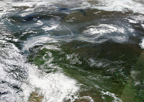
Hundreds of wildfires burned in northwest Canada and eastern Alaska, U.S.A. in late June 2024, sending smoke billowing eastward.
The Moderate Resolution Imaging Spectroradiometer (MODIS) on NASA’s Aqua satellite acquired a true-color image a gray smoky haze crossing Canada on June 30. The smoke crosses Northwest Territory (north), northern British Columbia (southwest), and northern Alberta (southeast).
Several red hotspots, each indicating actively burning fire, are located in British Columbia and Alberta. However, most of the fires were burning in the Yukon territory and eastern Alaska, both located west of the image.
On July 2, the Yukon government Emergencies and Safety published a wildfire update on their webpage that pinned a late June wildfire outbreak on lightning strikes. They stated that sustained lightning and dry forests have led to 86 new fires since storms began to develop on June 19. On the 19th, there were 12 active fires, of which only 1 required a full response. As of July 2, there were 78 active fires and 14 full responses. All but 2 of these full-response fires are burning in the Dawson and Mayo fire districts.
On the same day, British Columbia reported 86 wildfires in the province. Only 13 were listed as “out of control”, and all of those were in the northeastern section. Alberta listed 68 wildfires, most burning in the northern portion of the province. The Alaska Wildland Fire Dashboard showed 179 active fires on July 2. It also showed 269 lightning strikes on that date. Not every lightning strike is associated with fire, even in dry conditions.
Image Facts
Satellite:
Terra
Date Acquired: 6/30/2024
Resolutions:
1km (2.1 MB), 500m (6.7 MB),
Bands Used: 1,4,3
Image Credit:
MODIS Land Rapid Response Team, NASA GSFC
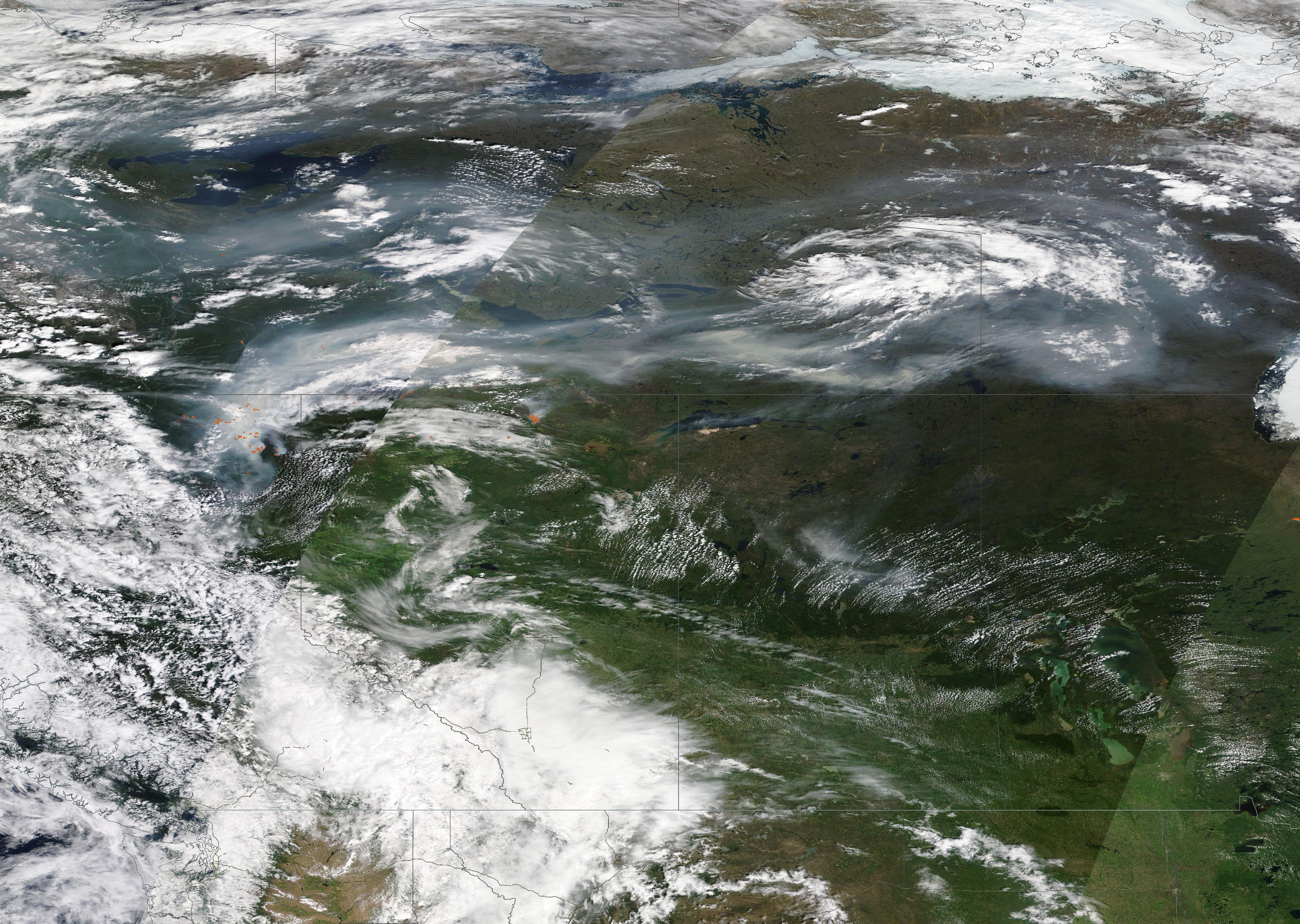
Hundreds of wildfires burned in northwest Canada and eastern Alaska, U.S.A. in late June 2024, sending smoke billowing eastward.
The Moderate Resolution Imaging Spectroradiometer (MODIS) on NASA’s Aqua satellite acquired a true-color image a gray smoky haze crossing Canada on June 30. The smoke crosses Northwest Territory (north), northern British Columbia (southwest), and northern Alberta (southeast). Several red hotspots, each indicating actively burning fire, are located in British Columbia and Alberta. However, most of the fires were burning in the Yukon territory and eastern Alaska, both located west of the image.
On July 2, the Yukon government Emergencies and Safety published a wildfire update on their webpage that pinned a late June wildfire outbreak on lightning strikes. They stated that sustained lightning and dry forests have led to 86 new fires since storms began to develop on June 19. On the 19th, there were 12 active fires, of which only 1 required a full response. As of July 2, there were 78 active fires and 14 full responses. All but 2 of these full-response fires are burning in the Dawson and Mayo fire districts.
On the same day, British Columbia reported 86 wildfires in the province. Only 13 were listed as “out of control”, and all of those were in the northeastern section. Alberta listed 68 wildfires, most burning in the northern portion of the province. The Alaska Wildland Fire Dashboard showed 179 active fires on July 2. It also showed 269 lightning strikes on that date. Not every lightning strike is associated with fire, even in dry conditions.
Image Facts
Satellite:
Terra
Date Acquired: 6/30/2024
Resolutions:
1km (2.1 MB), 500m (6.7 MB),
Bands Used: 1,4,3
Image Credit:
MODIS Land Rapid Response Team, NASA GSFC
