
Images


August 19, 2024 - A23a Keeps on Spinning


True-Color Image
Image with highlighted iceberg
Tweet
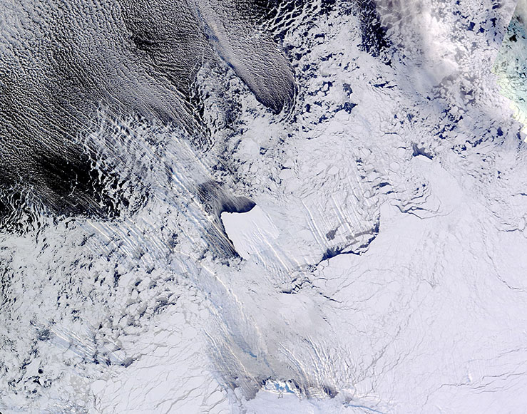
Iceberg A23a calved from the Filchner–Ronne Ice Shelf, on the northwestern side of Antarctica, in 1986. It quickly grounded in the Weddell Sea off the coast of West Antarctica where it was stuck until 2020, when it broke free. By March 2023 it appeared to be floating freely on ocean currents, heading northward. It passed the tip of the Antarctic Peninsula by November 2023 and seemed well on its way to transit “iceberg alley” and then ride currents to the Southern Ocean, the location that icebergs go to melt away.
By early 2023, satellite imagery showed the long-lived and massive iceberg had hit another snag —actually a vortex—that set it spinning and slowed northerly progress. The spin was expected to be temporary, but as of mid-August 2024, A23a, an iceberg spanning an area slightly larger than the state of Rhode Island, continues to spin.
Scientists say it has been trapped in a Taylor Column, which is type of rotating column of water. Such rotating currents happen when a fluid, such as a moving current of ocean water, strikes a submerged rise on the floor of the ocean. The forward-moving current splits into two columns as it passes the rise, and this creates a spin above the obstacle.
Scientists are not sure how long A23a may be stuck spinning in a lazy loop. It could be months or possibly even years before ocean dynamics or strong winds push the iceberg out of the spin-cycle and set it on its travels northward.
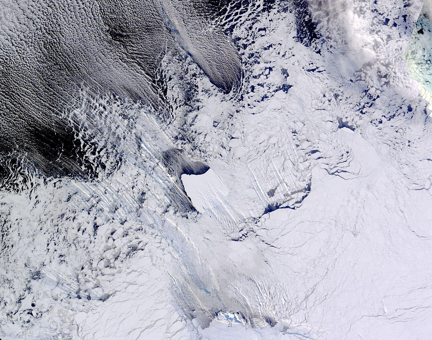
The Moderate Resolution Imaging Spectroradiometer (MODIS) on NASA’s Terra satellite acquired a true-color image of A23a located mid-slow-spin just north of the South Orkney Islands. The South Orkney islands lie just north of the Weddell Sea. In the original true-color image, seen here, the iceberg is partially obscured by clouds and other floating sea ice. Click on “Image with highlighted iceberg” to view the same true-color image, but with a blue line drawn around Iceberg A23a.
Image Facts
Satellite:
Terra
Date Acquired: 8/14/2024
Resolutions:
1km (218.6 KB), 500m (580.3 KB), 250m (1.5 MB)
Bands Used: 1,4,3
Image Credit:
MODIS Land Rapid Response Team, NASA GSFC
True-Color Image Image with highlighted iceberg
Iceberg A23a calved from the Filchner–Ronne Ice Shelf, on the northwestern side of Antarctica, in 1986. It quickly grounded in the Weddell Sea off the coast of West Antarctica where it was stuck until 2020, when it broke free. By March 2023 it appeared to be floating freely on ocean currents, heading northward. It passed the tip of the Antarctic Peninsula by November 2023 and seemed well on its way to transit “iceberg alley” and then ride currents to the Southern Ocean, the location that icebergs go to melt away.
By early 2023, satellite imagery showed the long-lived and massive iceberg had hit another snag —actually a vortex—that set it spinning and slowed northerly progress. The spin was expected to be temporary, but as of mid-August 2024, A23a, an iceberg spanning an area slightly larger than the state of Rhode Island, continues to spin.
Scientists say it has been trapped in a Taylor Column, which is type of rotating column of water. Such rotating currents happen when a fluid, such as a moving current of ocean water, strikes a submerged rise on the floor of the ocean. The forward-moving current splits into two columns as it passes the rise, and this creates a spin above the obstacle.
Scientists are not sure how long A23a may be stuck spinning in a lazy loop. It could be months or possibly even years before ocean dynamics or strong winds push the iceberg out of the spin-cycle and set it on its travels northward.
The Moderate Resolution Imaging Spectroradiometer (MODIS) on NASA’s Terra satellite acquired a true-color image of A23a located mid-slow-spin just north of the South Orkney Islands. The South Orkney islands lie just north of the Weddell Sea. In the original true-color image, seen here, the iceberg is partially obscured by clouds and other floating sea ice. Click on “Image with highlighted iceberg” to view the same true-color image, but with a blue line drawn around Iceberg A23a.
Image Facts
Satellite:
Terra
Date Acquired: 8/14/2024
Resolutions:
1km (218.6 KB), 500m (580.3 KB), 250m (1.5 MB)
Bands Used: 1,4,3
Image Credit:
MODIS Land Rapid Response Team, NASA GSFC
