
Images


October 10, 2024 - Hurricane Milton Takes Aim at Florida
 Tweet
Tweet
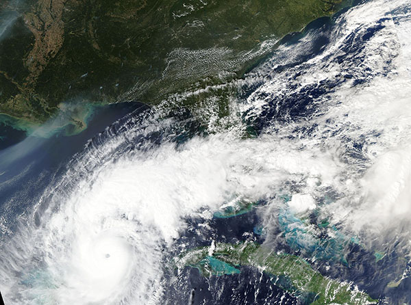
Hurricane Milton was a Category 5 storm taking dead aim for the western coast of Florida on October 8, 2024, when the Moderate Resolution Imaging Spectroradiometer (MODIS) on NASA’s Terra satellite acquired this true-color image.
Near the time this image was captured, the National Hurricane Center (NHC) advised that Milton carried maximum sustained winds of 165 mph (270 km/h). It was located over the Gulf of Mexico north of the Yucatan Peninsula, west of Cuba, and about 480 miles (775 km) southwest of Tampa, Florida. Facing wind shear, the storm had weakened from its peak of 180 mph (290 km/h), which it attained on October 7.
Efforts to prepare for landfall of this dangerous major hurricane were well underway when this image was acquired. Florida Governor DeSantis and the Seminole Tribe requested, and both were granted, pre-landfall federal Emergency Declarations, which enable the Federal Emergency Management Agency (FEMA) to provide direct assistance to state, local, and Tribal response, preposition federal supplies and response assets, and mobilize personnel.
Working in close coordination with the State, FEMA prepositioned more than 1,000 responders in the state, along with more than 1,400 Search and Rescue (SAR) personnel. The U.S. Coast Guard has 1,300 personnel ready to immediately assist and the U.S. Army Corps of Engineers is prepared to assess damage and open ports and critical infrastructure as quickly as possible. The State of Florida has also activated more than 6,000 National Guard members and expects to add another 3,000 to support State response activities. The State Emergency Operations Center was operating at Level 1 with nearly every State agency, and most Federal agencies, actively preparing to play a role in rescue and response to Hurricane Milton.
At 8:30 p.m. EDT, the NHC reported that extremely dangerous Category 3 Hurricane Milton made landfall near Siesta Key, Florida. It was carrying maximum sustained winds of about 120 mph (193 km/h) with stronger gusts. The storm was pushing life-threatening storm surge, extreme winds, and was triggering flash flooding across the Central Florida Peninsula at that time. Prior to landfall, Milton triggered several tornadoes on its northeastern side. Early reports showed tornadoes in Clewiston, Wellington, and Miramar, with touch downs suspected in these and other places.
Image Facts
Satellite:
Aqua
Date Acquired: 10/8/2024
Resolutions:
1km (975 KB), 500m (2.6 MB), 250m ( B)
Bands Used: 1,4,3
Image Credit:
MODIS Land Rapid Response Team, NASA GSFC
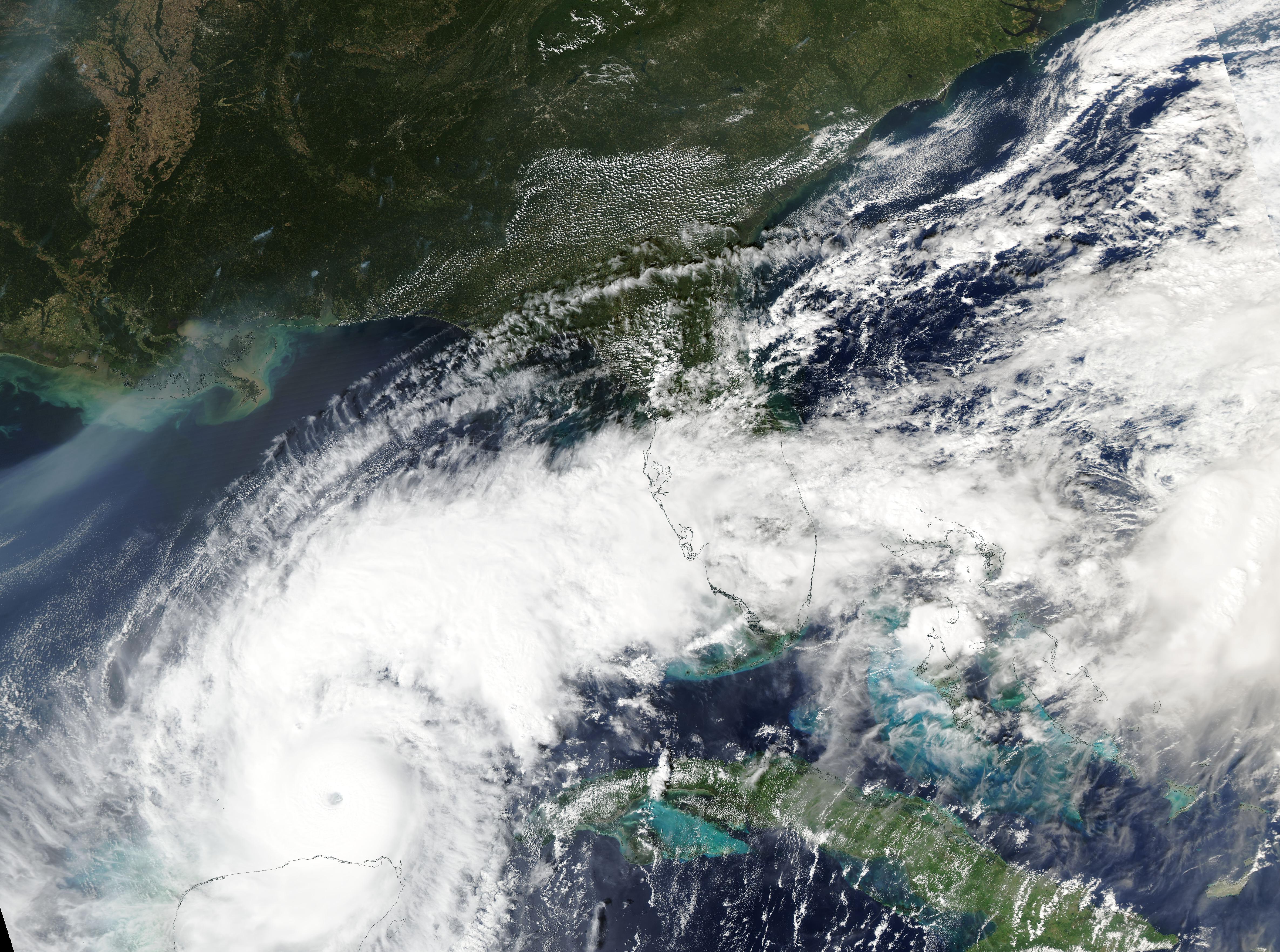
