
Images


October 14, 2024 - Cloud Streets and South Georgia Island
 Tweet
Tweet
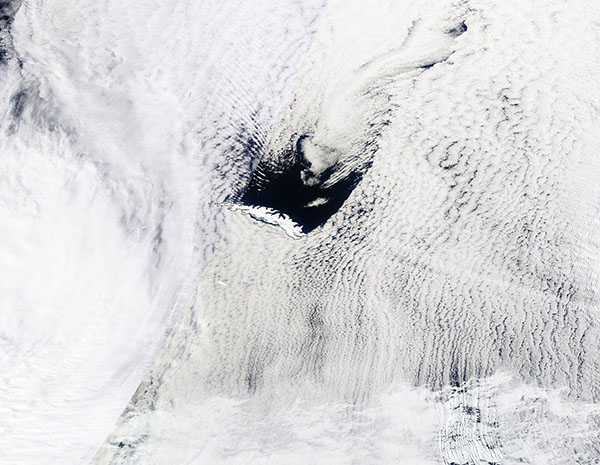
The skies around South Georgia Island were thick with cloud on October 9, 2024, when the Moderate Resolution Imaging Spectroradiometer (MODIS) on NASA’s Terra satellite acquired this true-color image. Clouds are common around the tiny island which sits in the remote Southern Atlantic Ocean roughly 800 miles (1,300 km) southeast of the nearest land—the Falkland Islands—and 1,700 miles (2,735 km) due east of the Argentina’s southernmost tip. It the largest island in the British overseas territory known as South Georgia and the South Sandwich Islands.
Several different patterns can be seen in the clouds around the island. The most prominent pattern is known as “cloud streets”. They earn their name because the clouds line up in parallel rows, much like lanes on an interstate. The rows are made up of a line of cloud and a cloud-free space.
Cloud streets occur when columns of heated air—thermals—rise through the atmosphere and carry heat away from the sea surface. The moist air rises until it hits a warmer air layer (a temperature inversion) that acts like a lid. The inversion causes the rising thermals to roll over on themselves, forming parallel cylinders of rotating air. On the upward side of the cylinders (rising air), water vapor condenses and forms clouds. Along the downward side (descending air), skies remain clear. Cloud streets also line up with the prevailing wind. In this case, the wind was generally moving from the north-northeast towards the south-southwest.
Image Facts
Satellite:
Terra
Date Acquired: 10/9/2024
Resolutions:
1km (57.6 KB), 500m (155.1 KB), 250m (373.5 KB)
Bands Used: 1,4,3
Image Credit:
MODIS Land Rapid Response Team, NASA GSFC
