Images
December 13, 2024 - Franklin Fire in California
Tweet
The combination of fierce Santa Ana winds and extremely low humidity raised Red Flag Warnings for extreme fire risk across much of Southern California in early December 2024.
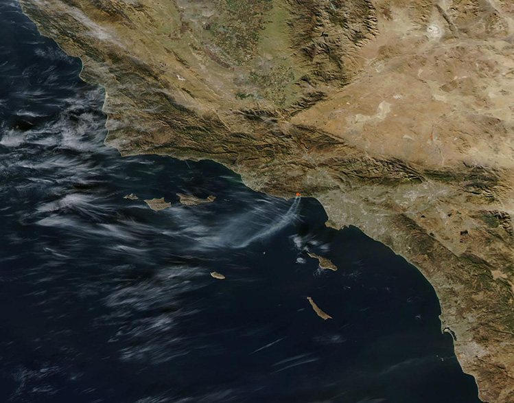
On the evening of December 9, a fire ignited near Pepperdine University’s 830-acre campus located in the foothills of the Santa Monica Mountains near Malibu, Los Angeles County. Thousands of students sheltering in place in safe campus buildings watched the hillside glow fiendishly red as the fire rapidly expanded. Fortunately, damage to the campus was minimal, with no injuries and only one building affected, according to media reports. That same night, however, the Franklin Fire swept southward, sprinting across the Pacific Coast Highway to reach the Malibu neighborhood of Serra Retreat, located only a mile from Malibu Pier on the Pacific Ocean.
On the afternoon of December 12, the Franklin Fire had scorched 4,307 acres and was 30 percent contained, according to CAL FIRE. Eleven structures had been damaged, twelve structures had been destroyed, and more than 4,321 structures remain threatened by the fire. Power outages and cell service disruptions were widespread since the beginning of the fire as power companies shut down service to high-risk regions to avoid risk of additional sparks or damage. At least 20,000 people faced evacuation orders, which are put in place when there is an immediate threat to life, with many more under evacuation warnings.
Fortunately, wind gusts slowed and humidity increased in the Malibu region on December 11 and 12. Red flag warnings were dropped across both Los Angeles County and the entire state as fire danger dropped. The improved conditions allowed firefighters to boost containment and assure safety to portions of the evacuation order zone. On December 12, at least 3,700 evacuees were permitted to return to their homes, according to media reports.
The Moderate Resolution Imaging Spectroradiometer (MODIS) on NASA’s Aqua satellite acquired this true-color image of the Franklin Fire on December 10. A large red “hot spot” shows the area of actively burning fire. A long plume of gray smoke rises from the fire and stretches more than 60 miles (96.6 km) to the southwest and over the Pacific Ocean.
Image Facts
Satellite:
Aqua
Date Acquired: 12/10/2024
Resolutions:
1km (46.4 KB), 500m (153.5 KB), 250m (479.7 KB)
Bands Used: 1,4,3
Image Credit:
MODIS Land Rapid Response Team, NASA GSFC


