Images
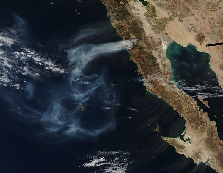
January 27, 2025 - Fires Scorch Northern Mexico
Tweet
Hot, dry weather and strong winds fueled wildland fires in Baja California in late January 2025. Seasonal Santa Ana winds blew in from dry areas inland and accelerated down the Sierra Juarez mountain range, creating conditions where a few sparks and small brush fires could quickly escalate.
The Moderate Resolution Imaging Spectroradiometer (MODIS) on NASA’s Aqua satellite captured this true-color image of smoke streaming from a large fire in the El Escondido area of Ensenada on January 23, 2025. The image was captured at 1:44 p.m. Pacific Time (21:44 Universal Time). Smoke pours from the fire and stretches far over the Pacific Ocean, passing over the Isla Guadelupe.
Mexico’s National Forestry Commission reported that the fire began on January 22 and had burned nearly 11,000 hectares (27,000 acres) by January 24. According to Baja California’s Civil Protection Office, winds exceeded 80 kilometers (50 miles) per hour as the fire burned. The region is also experiencing extreme drought conditions, according to the National Integrated Drought Information System.
The fire continued to burn through January 25, according to MODIS satellite imagery, although it appeared to have reduced in size. Clouds and rain moved in on January 26, bringing some relief to the region.
Image Facts
Satellite:
Aqua
Date Acquired: 1/23/2025
Resolutions:
1km (278.1 KB), 500m (651.7 KB), 250m (901.3 KB)
Bands Used: 1,4,3
Image Credit:
MODIS Land Rapid Response Team, NASA GSFC


