
Images


February 4, 2025 - Sediment in the Humber Estuary and the North Sea
 Tweet
Tweet
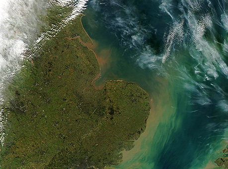
The Humber Estuary is the largest coastal estuary on the east coast of England, spanning a surface area of more than 30,550 hectares (75,492 acres). Draining about 20 percent of the total land surface of England, it collects fresh water and sediment from many rivers, including the Aire, Derwent, Ouse, Trent, and Don. These rivers spill into the estuary and ultimately pour sediment into the saline waters of the North Sea.
On February 2, 2025, the Moderate Resolution Imaging Spectroradiometer (MODIS) on NASA’s Terra satellite acquired this true-color image showing the stunning red and tan sediments filling the Humber Estuary and spilling into the North Sea.
The deeply muddy appearance of the estuary is caused by suspended sediment. According to the Humber Nature Partnership, about 3 percent of the sediment comes from rivers and 60 percent due to the North Sea (including tidal action on the shallow estuary). The remaining 37 percent comes from the eroding clay cliffs along the Holderness coast, which is laden with red pigment.
Image Facts
Satellite:
Terra
Date Acquired: 2/2/2025
Resolutions:
1km (102.5 KB), 500m (305.6 KB), 250m (700.4 KB)
Bands Used: 1,4,3
Image Credit:
MODIS Land Rapid Response Team, NASA GSFC
