
Images


April 18, 2025 - Tropical Cyclone Errol
 Tweet
Tweet
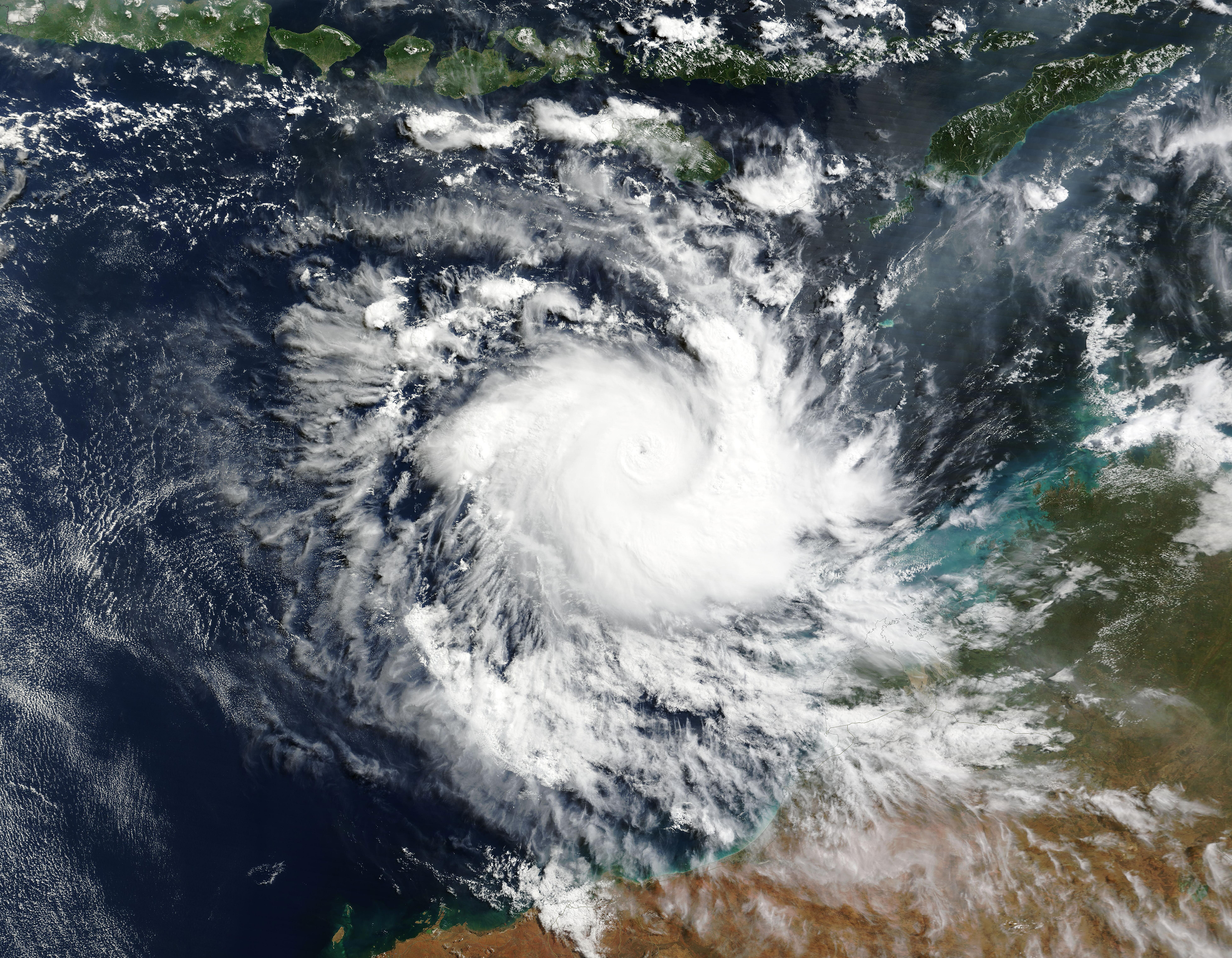
On April 16, 2025, the Moderate Resolution Imaging Spectroradiometer (MODIS) on NASA’s Terra satellite captured this true-color image of a ferocious Tropical Cyclone Errol threatening Western Australia. The storm sported a relatively small and cloud-filled eye and convective bands wrapped tightly around the center, giving Errol the apostrophe-like shape typical of many extremely strong cyclones. It was moving roughly parallel to the coast but would soon turn to take direct aim at the Kimberly coast.
Near the time the image was acquired, Tropical Storm Errol’s maximum sustained winds were about 140 miles per hour (225 km/h), according to Zoom Earth. That is the equivalent of a Category 4 storm on the Saffir-Simpson Hurricane Wind Scale—a storm capable of producing catastrophic damage. Errol became a Category 5 storm just a few hours later, reaching its peak strength of 160 miles per hour (257.5 km/h).
As Tropical Cyclone Errol turned to make a beeline towards the coast later that same day, it faced increased wind shear and winds began to drop. At 2100 UTC (5:00 p.m. EDT), the Joint Typhoon Warning Center (JTWC) advised maximum sustained winds were about 80.5 mph (130 km/h), which is equivalent to a Category 1 hurricane. It was located about 137 miles (220 km) north-northwest of Broome, Australia and was tracking east-southeastward.
The JTWC expects that Errol will continue to weaken as it fights wind shear and dry air as it approaches the coast.
Windspeeds at time of landfall are forecast to be between 46 and 52 miles per hour (74-83 km/h), which is well below Category 1 strength. The Australian Bureau of Meteorology issued a warning stating that Tropical Cyclone Errol is expected to cross the coast near Kuri Bay in the afternoon of April 18, local time with maximum sustained winds slightly less than those forecast by the JTWC. The much-weakened storm will still bring strong gusting winds and very heavy rains to the Kimberly coast. Local weather stations expect 50 mm (2 inches) of rain to fall in Western Australia, with some locations possibly getting a drenching of twice that amount.
Image Facts
Satellite:
Terra
Date Acquired: 4/16/2025
Resolutions:
1km (1.3 MB), 500m (3.6 MB), 250m (5.4 MB)
Bands Used: 1,4,3
Image Credit:
MODIS Land Rapid Response Team, NASA GSFC
On April 16, 2025, the Moderate Resolution Imaging Spectroradiometer (MODIS) on NASA’s Terra satellite captured this true-color image of a ferocious Tropical Cyclone Errol threatening Western Australia. The storm sported a relatively small and cloud-filled eye and convective bands wrapped tightly around the center, giving Errol the apostrophe-like shape typical of many extremely strong cyclones. It was moving roughly parallel to the coast but would soon turn to take direct aim at the Kimberly coast.
Near the time the image was acquired, Tropical Storm Errol’s maximum sustained winds were about 140 miles per hour (225 km/h), according to Zoom Earth. That is the equivalent of a Category 4 storm on the Saffir-Simpson Hurricane Wind Scale—a storm capable of producing catastrophic damage. Errol became a Category 5 storm just a few hours later, reaching its peak strength of 160 miles per hour (257.5 km/h).
As Tropical Cyclone Errol turned to make a beeline towards the coast later that same day, it faced increased wind shear and winds began to drop. At 2100 UTC (5:00 p.m. EDT), the Joint Typhoon Warning Center (JTWC) advised maximum sustained winds were about 80.5 mph (130 km/h), which is equivalent to a Category 1 hurricane. It was located about 137 miles (220 km) north-northwest of Broome, Australia and was tracking east-southeastward. The JTWC expects that Errol will continue to weaken as it fights wind shear and dry air as it approaches the coast.
Windspeeds at time of landfall are forecast to be between 46 and 52 miles per hour (74-83 km/h), which is well below Category 1 strength. The Australian Bureau of Meteorology issued a warning stating that Tropical Cyclone Errol is expected to cross the coast near Kuri Bay in the afternoon of April 18, local time with maximum sustained winds slightly less than those forecast by the JTWC. The much-weakened storm will still bring strong gusting winds and very heavy rains to the Kimberly coast. Local weather stations expect 50 mm (2 inches) of rain to fall in Western Australia, with some locations possibly getting a drenching of twice that amount.
Image Facts
Satellite:
Terra
Date Acquired: 4/16/2025
Resolutions:
1km (1.3 MB), 500m (3.6 MB), 250m (5.4 MB)
Bands Used: 1,4,3
Image Credit:
MODIS Land Rapid Response Team, NASA GSFC
