
Images


April 22, 2025 - Vegetative Regeneration in the Park Fire Burn Scar


April 14, 2025
July 30, 2024
Tweet
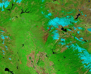
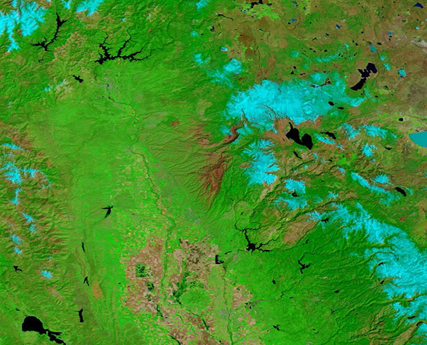
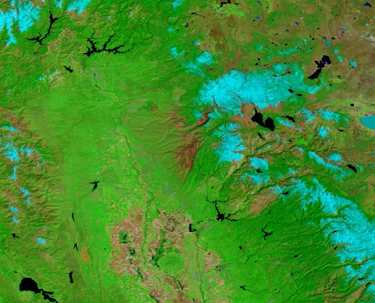
On the afternoon of July 24, 2024, a fire ignited in Upper Bidwell Park, the city of Chico, Butte County, California. By the time CALFIRE closed the incident, the Park Fire had scorched 429,603 acres in both Butte and Tehama counties. The flames destroyed 709 structures and damaged 54 more, according to a CALFIRE report in September 2024.
Once the fire had faded, a massive burn scar—an area where most vegetation had been completely destroyed—stretched over the landscape. A barren landscape charred by fire creates post-fire hazards. For one, burnt soil often will not absorb water easily, creating runoff and risk of flooding. Sediment runoff can deplete oxygen in streams and waterways, which in turn can kill aquatic plants and animals. Another risk is rapid return of invasive species of plants, which could choke out the return of plant species native to the landscape, and which are essential for recovery of the original ecosystem.
Post-fire mitigation is multi-faceted and includes creation of barriers to reduce the risk of landslides and to divert runoff away from aquatic ecosystems, as well as the more difficult task of discouraging invasives. The best practices for mitigation aim at stopping additional damage as well as encouraging plant growth within the burn scar. Given cooperative weather conditions, proper mitigation can spur rapid recovery in burn scars.
The Moderate Resolution Imaging Spectroradiometer (MODIS) on NASA’s Terra satellite acquired two false-color images of the Park Fire Burn scar, one on April 14, 2025, and one on July 30, 2024. Taken together, they illustrate the rapid recovery of much of the landscape after the high-intensity blaze. To toggle between the images, simply click on the dates.
In this type of false-color image, burn scars are colored in tones from tan to brick red and contrast sharply with vegetation, which is bright green. Ice and snow look electric blue while lakes and rivers show up as dark blue.
The top photo, acquired almost nine months after the fire started, shows snow atop the high Cascades, with some nearly encircling Lake Almanor. Due west of the lake, on the high western slopes of the Cascades, large patches of tan and brick red mark the burn scar of the Park Fire.
While this scar is large, comparing this April 14, 2025, image with the image acquired on July 30, 2024, shows truly impressive regeneration of vegetation. In July, orange flames and blue smoke marked active burning in the upper reaches of the fire while a vast swath in the lower elevations was charred.
Image Facts
Satellite:
Terra
Date Acquired: 4/14/2025
Resolutions:
1km (89.5 KB), 500m (199.8 KB), 250m (210.6 KB)
Bands Used: 7,2,1
Image Credit:
MODIS Land Rapid Response Team, NASA GSFC
April 14, 2025 July 30, 2024
On the afternoon of July 24, 2024, a fire ignited in Upper Bidwell Park, the city of Chico, Butte County, California. By the time CALFIRE closed the incident, the Park Fire had scorched 429,603 acres in both Butte and Tehama counties. The flames destroyed 709 structures and damaged 54 more, according to a CALFIRE report in September 2024.
Once the fire had faded, a massive burn scar—an area where most vegetation had been completely destroyed—stretched over the landscape. A barren landscape charred by fire creates post-fire hazards. For one, burnt soil often will not absorb water easily, creating runoff and risk of flooding. Sediment runoff can deplete oxygen in streams and waterways, which in turn can kill aquatic plants and animals. Another risk is rapid return of invasive species of plants, which could choke out the return of plant species native to the landscape, and which are essential for recovery of the original ecosystem.
Post-fire mitigation is multi-faceted and includes creation of barriers to reduce the risk of landslides and to divert runoff away from aquatic ecosystems, as well as the more difficult task of discouraging invasives. The best practices for mitigation aim at stopping additional damage as well as encouraging plant growth within the burn scar. Given cooperative weather conditions, proper mitigation can spur rapid recovery in burn scars.
The Moderate Resolution Imaging Spectroradiometer (MODIS) on NASA’s Terra satellite acquired two false-color images of the Park Fire Burn scar, one on April 14, 2025, and one on July 30, 2024. Taken together, they illustrate the rapid recovery of much of the landscape after the high-intensity blaze. To toggle between the images, simply click on the dates.
In this type of false-color image, burn scars are colored in tones from tan to brick red and contrast sharply with vegetation, which is bright green. Ice and snow look electric blue while lakes and rivers show up as dark blue. The top photo, acquired almost nine months after the fire started, shows snow atop the high Cascades, with some nearly encircling Lake Almanor. Due west of the lake, on the high western slopes of the Cascades, large patches of tan and brick red mark the burn scar of the Park Fire.
While this scar is large, comparing this April 14, 2025, image with the image acquired on July 30, 2024, shows truly impressive regeneration of vegetation. In July, orange flames and blue smoke marked active burning in the upper reaches of the fire while a vast swath in the lower elevations was charred.
Image Facts
Satellite:
Terra
Date Acquired: 4/14/2025
Resolutions:
1km (89.5 KB), 500m (199.8 KB), 250m (210.6 KB)
Bands Used: 7,2,1
Image Credit:
MODIS Land Rapid Response Team, NASA GSFC
