
Images


April 30, 2025 - Spring Thaw in Minnesota


April 24, 2025
April 7, 2025
Tweet
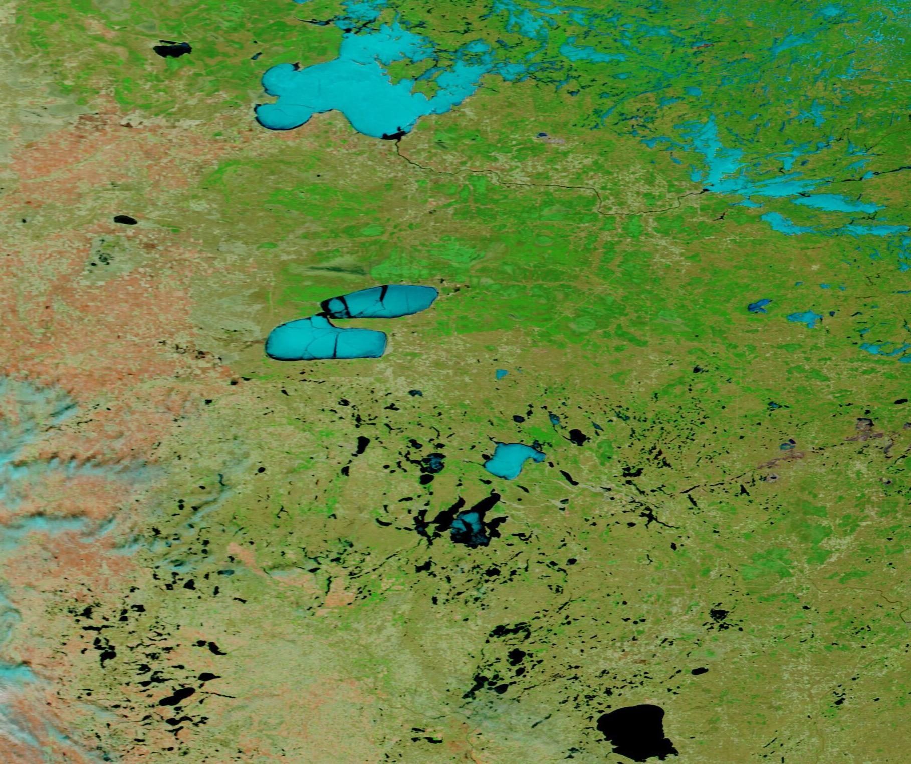
Lengthening daylight and rising temperatures spurred rapid ice melt on several lakes in northcentral Minnesota in mid-April 2025. The Moderate Resolution Imaging Spectroradiometer (MODIS) on NASA’s Terra satellite acquired this pair of false-color images on April 24 and April 24 that show the change created by just a few weeks of warming springtime weather.
This type of false-color image helps separate snow and ice, which looks bright electric blue, from open water, which shows up as dark blue or black. In addition, open land is tan, and vegetation appears bright green. Each image can be viewed by clicking on the appropriate date below the image.
On April 24, the ice on Red Lakes—a pair of lakes in the center of the image—clearly show substantial melting, with open water along the shorelines and large cracks in floating ice. In the north, the Lake of the Woods, which spans the border with Canada, appears to be more solid but also shows open water along the shoreline and relatively small cracking. To the south of Red Lakes, almost all lakes and rivers show open water.
Clicking on the April 7 title reveals a much different scene of the same area. On that date, the ice on Lake of the Woods and Red Lakes looks bright and appears solid, with no cracks or open water visible anywhere. The same is true for most of the lakes to the south, except for the largest one near the lower right border of the image, which shows a thin margin of open water along the northern shoreline.
Image Facts
Satellite:
Terra
Date Acquired: 4/24/2025
Resolutions:
1km (278.6 KB), 500m (682.7 KB), 250m (422.6 KB)
Bands Used: 7,2,1
Image Credit:
MODIS Land Rapid Response Team, NASA GSFC
April 24, 2025 April 7, 2025
Lengthening daylight and rising temperatures spurred rapid ice melt on several lakes in northcentral Minnesota in mid-April 2025. The Moderate Resolution Imaging Spectroradiometer (MODIS) on NASA’s Terra satellite acquired this pair of false-color images on April 24 and April 24 that show the change created by just a few weeks of warming springtime weather.
This type of false-color image helps separate snow and ice, which looks bright electric blue, from open water, which shows up as dark blue or black. In addition, open land is tan, and vegetation appears bright green. Each image can be viewed by clicking on the appropriate date below the image.
On April 24, the ice on Red Lakes—a pair of lakes in the center of the image—clearly show substantial melting, with open water along the shorelines and large cracks in floating ice. In the north, the Lake of the Woods, which spans the border with Canada, appears to be more solid but also shows open water along the shoreline and relatively small cracking. To the south of Red Lakes, almost all lakes and rivers show open water.
Clicking on the April 7 title reveals a much different scene of the same area. On that date, the ice on Lake of the Woods and Red Lakes looks bright and appears solid, with no cracks or open water visible anywhere. The same is true for most of the lakes to the south, except for the largest one near the lower right border of the image, which shows a thin margin of open water along the northern shoreline.
Image Facts
Satellite:
Terra
Date Acquired: 4/24/2025
Resolutions:
1km (278.6 KB), 500m (682.7 KB), 250m (422.6 KB)
Bands Used: 7,2,1
Image Credit:
MODIS Land Rapid Response Team, NASA GSFC
