
Images


October 15, 2024 - Northeast Oman
 Tweet
Tweet
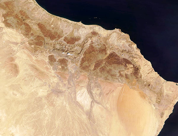
A sunny autumn day lit up the rugged, arid terrain of northeastern Oman on October 10, 2024. The Moderate Resolution Imaging Spectroradiometer (MODIS) on NASA’s Terra satellite acquired this true-color image on the same day.
In contrast to much of the rest of the country, which is rich in orange-tinted sands, the predominant colors of the rugged and rocky Al Hajar mountains range from pale beige to a deep green-brown. Al Hajar is known as the largest mountain range in eastern Arabia. It stretches roughly parallel to the coastline for about 430 miles (700 km) through Oman and, in the west, into the United Arab Republic. The tallest peak, Jabal Shams, rises to 9,872 feet (3,009 meters) in the central region.
The mountains are classified as a mountain desert, with average annual rainfall of 400 mm (15.7 inches) or less. Most of the time, the region remains quite dry but when rain does fall, it encourages a burst of green vegetation. Parts of Al Hajar received rain the first week of October and the high-resolution image shows some greening. And more rain is in the forecast.
On October 14,the Civil Aviation Authority’s Directorate General of Meteorology had issued a weather alert for heavy rainfall from a potential tropical system forming in the Arabian Sea, just east of this image. The alert covers most of the country and forecasts heavy thunderstorms with rain of 1-3 inches (3-8 cm possible), strong winds, possible hail and flash flooding, especially in wadis (dry riverbeds). The storm is expected to start along the southeastern and central coast on the evening of October 14 then cover most of the rest of Oman through October 16.
Image Facts
Satellite:
Terra
Date Acquired: 10/10/2024
Resolutions:
1km (52 KB), 500m (130.5 KB), 250m (266.5 KB)
Bands Used: 1,4,3
Image Credit:
MODIS Land Rapid Response Team, NASA GSFC
