
Images


June 4, 2024 - Spring Ice Breakup on the Beaufort Sea and Amundsen Gulf


June 2, 2024
May 2, 2024
Tweet
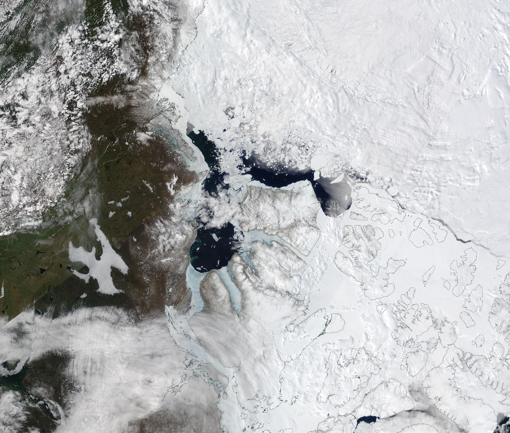
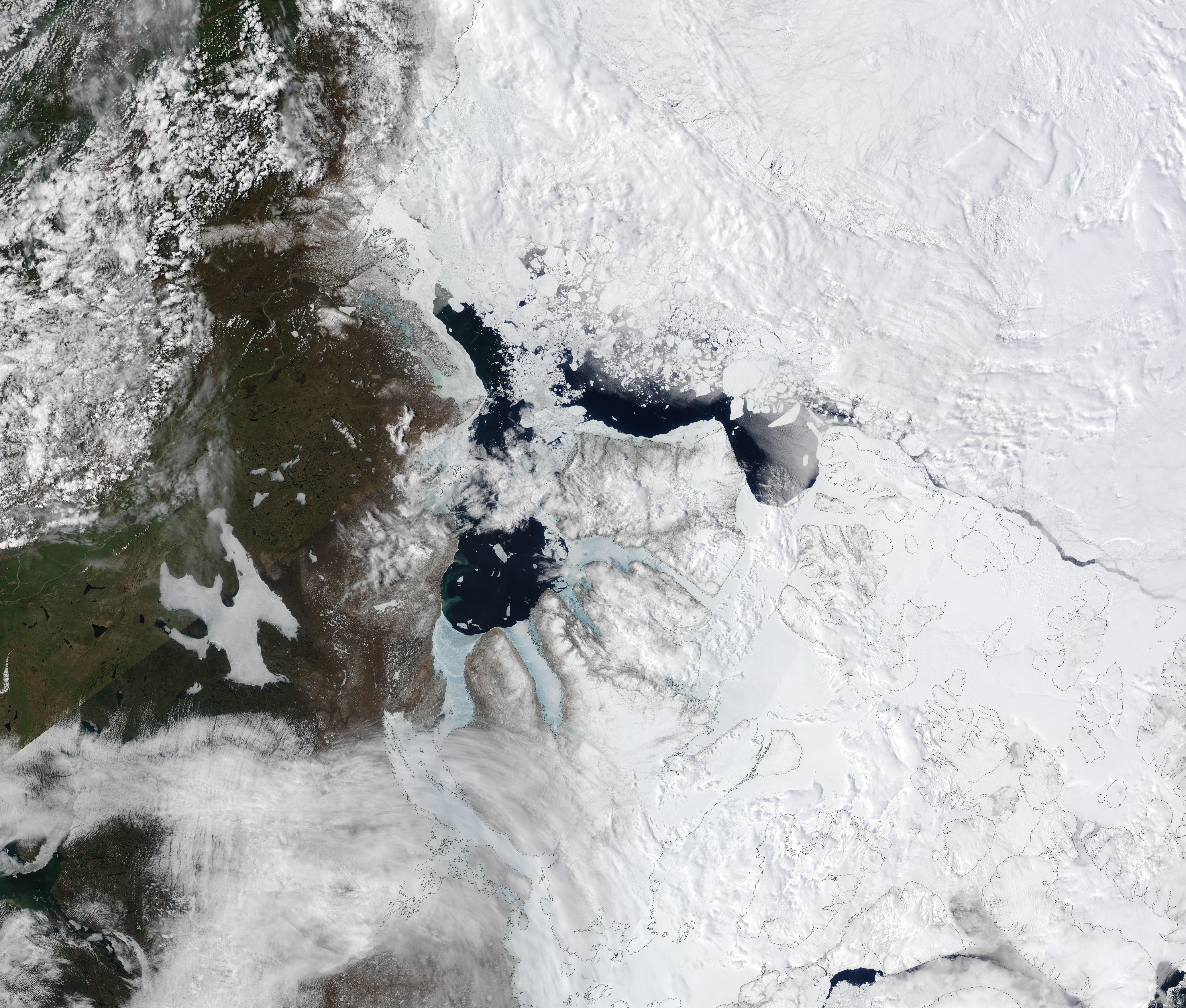
Each winter, frigid temperatures and shortening daylight triggers the freeze-up of both the Beaufort Sea and its extension, northern Canada’s Amundsen Gulf. Most of the ice in Amundsen Gulf is typically “fast ice,” a type of ice that is “fastened” to the surrounding coastlines.
Arctic sea ice reaches its maximum extent near mid-March, then begins to slowly wane in the lengthening daylight and rising temperatures of spring. The breakup in Amundsen Gulf tends to begin by late May—and usually happens quickly, with ice-free water expanding over the course of a few weeks.
The Moderate Resolution Imaging Spectroradiometer (MODIS) on NASA’s Aqua satellite acquired a true-color image of ice breakup off the coast of northern Canada on June 2, 2024. At that time, ice still remained on parts of the Amundsen Gulf that lay between several islands and the mainland, and the Beaufort Sea remained mostly covered with floating sea ice. But a large pocket of fast ice along the Canadian shore near where the Beaufort Sea meets the Amundsen Gulf had melted. Ice and snow had also retreated from much of the mainland.
Compare this image with a second Aqua MODIS image acquired a month earlier, on May 2, 2024. In the May image, which can be viewed by clicking on the date below, a thick layer of ice covers both the Beaufort Sea and the Amundsen Gulf. Thin black lines have been overlain on the scene to mark the coastal boundaries of the many islands in the region as well as the coastal margin of the mainland.
Image Facts
Satellite:
Aqua
Date Acquired: 6/2/2024
Resolutions:
1km (692.5 KB), 500m (2.3 MB), 250m (2.3 MB)
Bands Used: 1,4,3
Image Credit:
MODIS Land Rapid Response Team, NASA GSFC
June 2, 2024 May 2, 2024
Each winter, frigid temperatures and shortening daylight triggers the freeze-up of both the Beaufort Sea and its extension, northern Canada’s Amundsen Gulf. Most of the ice in Amundsen Gulf is typically “fast ice,” a type of ice that is “fastened” to the surrounding coastlines.
Arctic sea ice reaches its maximum extent near mid-March, then begins to slowly wane in the lengthening daylight and rising temperatures of spring. The breakup in Amundsen Gulf tends to begin by late May—and usually happens quickly, with ice-free water expanding over the course of a few weeks.
The Moderate Resolution Imaging Spectroradiometer (MODIS) on NASA’s Aqua satellite acquired a true-color image of ice breakup off the coast of northern Canada on June 2, 2024. At that time, ice still remained on parts of the Amundsen Gulf that lay between several islands and the mainland, and the Beaufort Sea remained mostly covered with floating sea ice. But a large pocket of fast ice along the Canadian shore near where the Beaufort Sea meets the Amundsen Gulf had melted. Ice and snow had also retreated from much of the mainland.
Compare this image with a second Aqua MODIS image acquired a month earlier, on May 2, 2024. In the May image, which can be viewed by clicking on the date below, a thick layer of ice covers both the Beaufort Sea and the Amundsen Gulf. Thin black lines have been overlain on the scene to mark the coastal boundaries of the many islands in the region as well as the coastal margin of the mainland.
Image Facts
Satellite:
Aqua
Date Acquired: 6/2/2024
Resolutions:
1km (692.5 KB), 500m (2.3 MB), 250m (2.3 MB)
Bands Used: 1,4,3
Image Credit:
MODIS Land Rapid Response Team, NASA GSFC
