Images
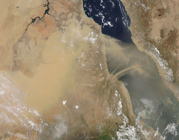
August 17, 2017 - Dust storm over Sudan and the Red Sea
Tweet
On August 12, 2017, the Moderate Resolution Imaging Spectroradiometer (MODIS) aboard NASA’s Terra satellite acquired a true-color image of a massive dust storm over Sudan. A thick layer of sand and dust obscured much of the arid land of Sudan while strong winds pushed the particulate matter over the blue water of the Red Sea.
Dust and sand storms are one of the most common natural hazards of Sudan, and can create significant difficulties with transportation and visibility. The blowing dust can also create severe health hazards. In 2015, one severe dust storm swept across seven countries in the Middle East leaving at least twelve people dead.
Summertime is the prime time for dust storms across the region, when strong, often violent, winds drive walls of sand across the desert. Known as haboobs, such storms can create a wall of sand that rises more than 3,000 feet and may contain winds of up to 70 mph (112 km/h), which makes them only slightly weaker than the winds found in a Category 1 hurricane (75 mph or 120 km/h). Haboobs typically last no more than three hours, but the effects can be disruptive to travel and health for an extended time after the passing of the initial wall of dust.
Image Facts
Satellite:
Terra
Date Acquired: 8/12/2017
Resolutions:
1km (263.8 KB), 500m (864.5 KB), 250m (2.2 MB)
Bands Used: 1,4,3
Image Credit:
Jeff Schmaltz, MODIS Land Rapid Response Team, NASA GSFC


