
Images


May 9, 2018 - Barotse Floodplain
 Tweet
Tweet
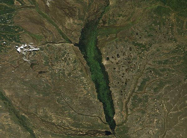
The Barotse Floodplain spans more than 2,123 square miles (5,500 sq. km) along the upper Zambezi River near the border with Angola. During the rainy season (October to May), the river overflows so strongly that the inundated area can expand to about 4,150 square miles (10,750 sq. mi) when the floodplains of several major tributaries are also counted.
This vast wetlands is part of the Western Zambezian grasslands ecosystem, lying at around 1,000 meters elevation. The large, slightly undulating grassy plains are drained by the Zambezi and its tributaries. The annual flooding enriches the floodplains and the grass grows quickly as the waters recede after in May through June.
The ebb and flow of the river plays an important role in the life of the Lozi people who have lived in the region for centuries. Large celebrations mark both the peak flooding and the retreat of the waters, while the onset of the dry season brings intense agricultural activity on the fertile floodplain. The lives of birds and beasts are also tied to the flooding. The largest herd of wildebeest living in Zambia make a spectacular migration each year into Angola – and back again. A number of birds, such as the Rufous-bellied Heron, African Skimmer, and African Openbill, depend on the wetlands.
The Moderate Resolution Imaging Spectroradiometer (MODIS) aboard NASA’s Terra satellite acquired a true-color image of the Barotse Floodplain on May 7, 2018. The flood waters are near peak but have begun to recede.
Image Facts
Satellite:
Terra
Date Acquired: 5/7/2018
Resolutions:
1km (62.4 KB), 500m (159.7 KB), 250m (187.2 KB)
Bands Used: 1,4,3
Image Credit:
Jeff Schmaltz, MODIS Land Rapid Response Team, NASA GSFC
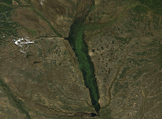
