Images
September 9, 2018 - Hurricane Florence
Tweet
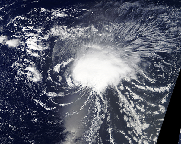
On September 6, 2018, the Moderate Resolution Imaging Spectroradiometer (MODIS) on board NASA’s Terra satellite acquired a true-color image of Hurricane Florence, the first major hurricane of the Atlantic hurricane season.
The National Hurricane Center (NHC) issued its first advisory on the system on the morning of August 30, when Potential Tropical Cyclone Six was expected to impact the southern Cape Verde Islands with rain and tropical storm-force winds. By September 1 the system had strengthened enough to be named as a tropical storm as it moved westward over the Atlantic, but still remaining close to the coast of western Africa.
Tropical Storm Florence continued to pick up power as it entered the central Atlantic and reached hurricane strength on the morning of September 4. Rapidly intensifying, Florence reached Category 3 status at 8:35 a.m. EDT (12:35 UTC) on September 5, with maximum sustained winds reported at 125 mph (195 km/h). At that time, the NHC reported that Hurricane Florence was located about 1,185 miles (1910 km) east northeast of the northern Leeward Islands and about 1,405 miles (2,265 km) east southeast of Bermuda. It was moving west-northwest at 10 mph (17 km/h). By 5:00 p.m. that same day Florence became a Category 4 hurricane with maximum sustained winds of 130 mph (215 km/h) despite facing increasing wind shear.
On the morning of September 6, Florence’s battle with wind shear became more intense. As the morning NHC bulletin arrived, Hurricane Florence’s winds had dropped to 115 mph (185 km/h) (Category 3). By the end of the day Florence had reached Tropical Storm status once again, with maximum sustained winds of 70 mph (110 km/h). The NHC forecast additional weakening before the storm strengthened again – and Florence has cooperated with that predication. Maximum sustained winds dropped to a low of 60 mph (96.5 km/h) by the evening of September 7.
At 5:00 p.m. EDT (21:00 UTC) the NHC reported that Florence was again strengthening, with maximum sustained winds reaching 70 mph (110 km/h). Tropical Storm Florence was located at about 810 miles (1,305 km) southeast of Bermuda and about 695 mi (1,120 km) northeast of the northern Leeward Islands. It was moving westward at 5 mph (7 km/h).
It is expected that Florence will reach hurricane status (winds over 75 mph) by the morning of September 9. A west-northwestward to northwestward motion with an increase in forward speed is expected by the middle of next week. The storm is expected to move over the southwestern Atlantic Ocean between Bermuda and the Bahamas Tuesday and Wednesday and approach the southeastern coast of the United States on Thursday, September 13.
Image Facts
Satellite:
Terra
Date Acquired: 9/6/2018
Resolutions:
1km (3 MB), 500m (8.2 MB), 250m (7.1 MB)
Bands Used: 1,4,3
Image Credit:
MODIS Land Rapid Response Team, NASA GSFC


