
Images


October 20, 2018 - Niger River, Mali
 Tweet
Tweet
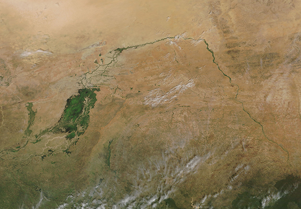
The Niger River courses along a crescent shape through parched, landlocked Mali. The third-longest river in Africa, the Niger skirts the edge of the Sahara Desert before turning southward to join the Bani River. The confluence of the two rivers – and a network of smaller streams – gives rise to the Inland Niger Delta, a green oasis comprised of twisting waterways and tiny islands.
The size of the Inland Delta depends on the season - the delta grows to about 20,000 square kilometers (7,700 square miles) during the four-month rainy season that begins in July and can shrink to about 3,900 square kilometers (1,500 square miles) during the dry season.
The Moderate Resolution Imaging Spectroradiometer (MODIS) on board NASA’s Terra satellite acquired a true-color image of the Niger River as it makes its way across Mali and the green Inland Niger Delta on October 17, 2018.
Image Facts
Satellite:
Terra
Date Acquired: 10/17/2018
Resolutions:
1km (754.4 KB), 500m (2 MB), 250m (1.6 MB)
Bands Used: 1,4,3
Image Credit:
MODIS Land Rapid Response Team, NASA GSFC
