
Images


November 16, 2019 - Typhoon Fengshen off Guam
 Tweet
Tweet
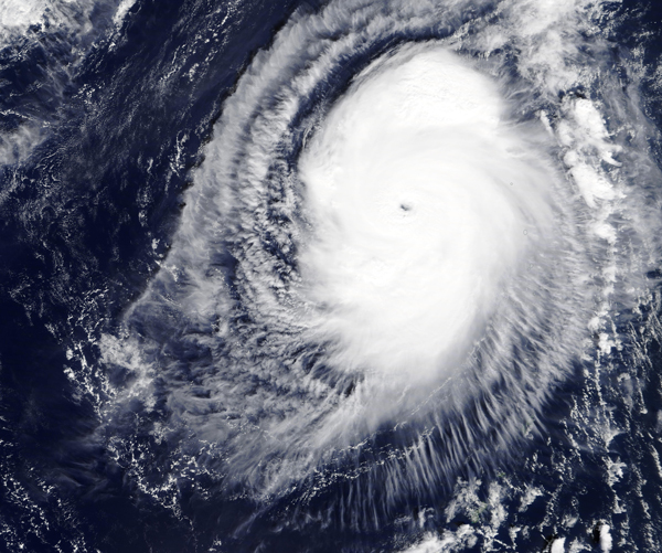
Tropical storm Fengshen went through very rapid intensification from November 14-15, 2019, with maximum one-minute wind speeds increasing from 65 mph (104.6 km/h) to 127 mph (204 km/h) within roughly 24 hours. By the time NASA’s Terra satellite passed overhead on November 15, allowing the Moderate Resolution Imaging Spectroradiometer (MODIS) on board to acquire a true-color image of the storm, Typhoon Fengshen had developed a small, cloud-free eye with strong bands of thunderstorms wrapping into the center.
At 5 a.m. EDT (0900 UTC) that same day, the center of Typhoon Fengshen was located near latitude 21.6 degrees north and longitude 142.3 degrees east. That is about 227 nautical miles south-southeast of Iwo To Island, Japan. Fengshen has tracked to the north-northwest. Maximum sustained winds were near 127 mph (204 km/h) at that time.
The Joint Typhoon Warning Center expected slight strengthening over the day on November 15 before a weakening trend begins on November 16. The storm is expected to make a loop over the next five days and head toward the northwest by November 19, passing to the northeast of Iwo To.
Image Facts
Satellite:
Terra
Date Acquired: 11/15/2019
Resolutions:
1km (1.2 MB), 500m (3.5 MB), 250m (2.8 MB)
Bands Used: 1,4,3
Image Credit:
MODIS Land Rapid Response Team, NASA GSFC
