Images
December 29, 2019 - Solar Eclipse over Southeast Asia
Tweet
On December 26, 2019, a spectacular solar eclipse swept across a roughly 73-mile-wide path from Saudi Arabia, to Oman, southern India, Singapore, and the Northern Mariana Islands. The time of totality lasted roughly 4 minutes, from 05:26:40 UTC (12:26:40 EST) to 5:30:20 UTC 12:30:30 EST), and was accompanied by a stunning “ring of fire” effect, in which the moon was surrounded completely by a rim of brilliance from the Sun.
This type of eclipse is known as an “annular eclipse” and occurs when the Moon is closer to its apogee (when it’s farther away from Earth). At this point it appears about 3 percent smaller than the Sun when viewed from Earth, which leaves a bit of brilliant Sun showing around the dark Moon.
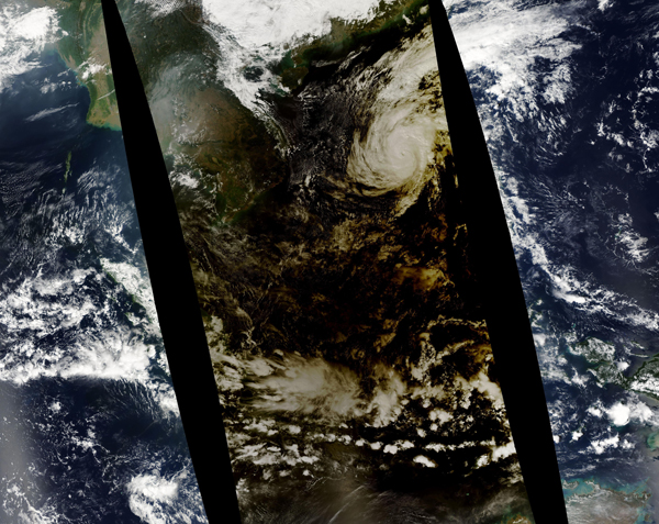
As eclipse chasers and citizens were looking up in Southeast Asia, NASA’s Aqua satellite was looking down. The Moderate Resolution Imaging Spectroradiometer (MODIS) on that satellite captured this true-color image of the Moon’s shadow on December 26, as the eclipse traveled eastward across the South China Sea towards the Indian Ocean. The shadow cast by an eclipse consists of the completely darkened umbra and the partially shadowed penumbra.
The MODIS sensor on the Aqua satellite collects imagery in swaths that are roughly 2,330 kilometers (1,450 miles) wide. This image is a mosaic comprised of data collected at three different times. The black gaps in the image are places near the Equator (Earth’s widest point) where MODIS swaths do not meet on a given day.
Image Facts
Satellite:
Aqua
Date Acquired: 12/26/2019
Resolutions:
1km (664.9 KB),
Bands Used: 1,4,3
Image Credit:
MODIS Land Rapid Response Team, NASA GSFC


