
Images


February 4, 2020 - Burn Scars in Australia
 Tweet
Tweet
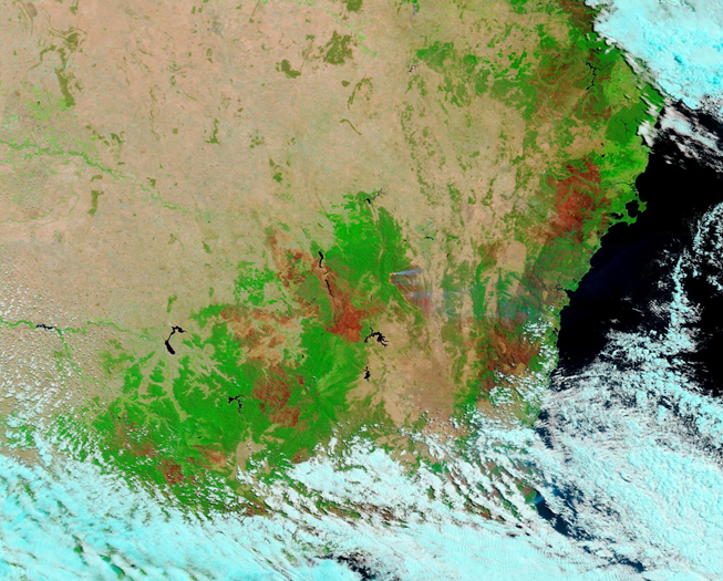
Australia’s 2019-2020 fire season has been particularly vicious, with more than 3,000 homes destroyed, more than 26.2 million acres (10.6 million hectares) burnt, and 33 lives lost since September in New South Wales and Victoria states. The seemingly endless fires and vast clouds of smoke have led many to call this season “Black Summer”. While rains have come to southeastern Australia in recent days, some fires continue to burn – and some with great fury.
On January 27, the Orroral Valley Fire was started from a firefighting helicopter’s landing lights, which were hot enough to spark a fire in tinder-dry, hot conditions. In just one week, this fire roared through about 155,646 acres (62,988 hectares) in and around the Namadgi National Park in the Canberra region, according to the Australian Territory Emergency Services Agency’s report on February 4. The fire continues to burn, especially on the western edge.
As fires burn, they consume or damage vegetation and may leave charred ground and ash behind, leaving scars that can be seen from space. On February 3, 2020, the Moderate Resolution Imaging Spectroradiometer (MODIS) on board NASA’s Aqua satellite acquired a false color image of fire scars across southeastern Australia. The false-color image, using bands 7,2,1, shows vegetation as electric green, smoke as electric blue, water deep blue, and open land as tan.. The color of the scar reflects the unique damage left by the fire, so the color in the fire scars range from a charred black color to brick red.
Just below the center of the image, smoke rises from red hotspots, which mark actively burning fire. This is the location of the Orroral Fire, which was highly active at the time. Clouds covering the coast are bringing needed rain.
Thanks to the NASA Worldview app, a stunning comparison of the area on February 3, 2020 and December 5, 2019 can be seen HERE
The NASA Worldview app provides a satellite's perspective of the planet as it looks today and as it has in the past. Worldview is part of NASA’s Earth Observing System Data and Information System. EOSDIS makes the agency's large repository of data accessible and freely available to the public.
Image Facts
Satellite:
Aqua
Date Acquired: 2/3/2020
Resolutions:
1km (437 KB), 500m (1 MB), 250m (825 KB)
Bands Used: 7,2,1
Image Credit:
MODIS Land Rapid Response Team, NASA GSFC
Australia’s 2019-2020 fire season has been particularly vicious, with more than 3,000 homes destroyed, more than 26.2 million acres (10.6 million hectares) burnt, and 33 lives lost since September in New South Wales and Victoria states. The seemingly endless fires and vast clouds of smoke have led many to call this season “Black Summer”. While rains have come to southeastern Australia in recent days, some fires continue to burn – and some with great fury.
On January 27, the Orroral Valley Fire was started from a firefighting helicopter’s landing lights, which were hot enough to spark a fire in tinder-dry, hot conditions. In just one week, this fire roared through about 155,646 acres (62,988 hectares) in and around the Namadgi National Park in the Canberra region, according to the Australian Territory Emergency Services Agency’s report on February 4. The fire continues to burn, especially on the western edge.
As fires burn, they consume or damage vegetation and may leave charred ground and ash behind, leaving scars that can be seen from space. On February 3, 2020, the Moderate Resolution Imaging Spectroradiometer (MODIS) on board NASA’s Aqua satellite acquired a false color image of fire scars across southeastern Australia. The false-color image, using bands 7,2,1, shows vegetation as electric green, smoke as electric blue, water deep blue, and open land as tan.. The color of the scar reflects the unique damage left by the fire, so the color in the fire scars range from a charred black color to brick red. Just below the center of the image, smoke rises from red hotspots, which mark actively burning fire. This is the location of the Orroral Fire, which was highly active at the time. Clouds covering the coast are bringing needed rain.
Thanks to the NASA Worldview app, a stunning comparison of the area on February 3, 2020 and December 5, 2019 can be seen HERE
The NASA Worldview app provides a satellite's perspective of the planet as it looks today and as it has in the past. Worldview is part of NASA’s Earth Observing System Data and Information System. EOSDIS makes the agency's large repository of data accessible and freely available to the public.
Image Facts
Satellite:
Aqua
Date Acquired: 2/3/2020
Resolutions:
1km (437 KB), 500m (1 MB), 250m (825 KB)
Bands Used: 7,2,1
Image Credit:
MODIS Land Rapid Response Team, NASA GSFC
