
Images


May 22, 2020 - Flooding in Michigan
 Tweet
Tweet
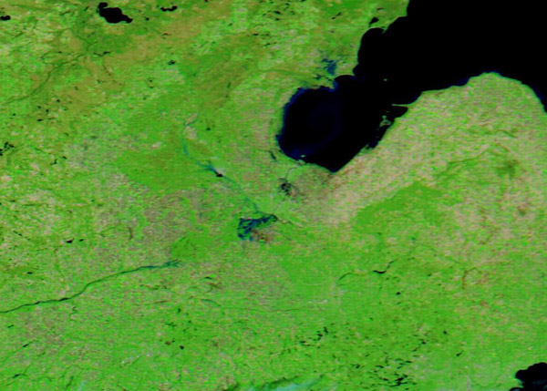
On May 17, 2020, heavy rain began pouring over central Michigan and, after two days, it provoked significant flooding in Midland County. Local media reported that rushing waters downed trees and damaged roadways, homes and businesses, including damage to the City of Midland. The accumulating rainfall also led to catastrophic dam failures that swelled rivers and streams and inundated several nearby communities. The governor ordered more than 10,000 residents of Edenville and Sanford to evacuate.
The National Weather Service reported record rainfall where more than 4 inches (10 centimeters) fell across parts of Midland in 48 hours. The Edenville Dam then collapsed on the evening of May 19, sending floodwaters south across the landscape. About an hour later, water spilled over the Sanford Dam and further flooded the Tittabawassee River and the surrounding area.
On May 20, the Tittabawassee River reached a height just over 35 feet (11 meters)—about four feet higher than levels in the devastating 1986 floods. The governor has declared a state of emergency. The initial estimate of damage to buildings from the failure of the Edenville Dam at 5,745 parcels with a total building value of $878,974,848.
On May 20, 2020, the Moderate Resolution Imaging Spectroradiometer (MODIS) on board NASA’s Terra satellite acquired a false-color image highlighting the flooding in Midland County, Michigan.
This type of image, using bands 7,2,1, combines infrared and visible light in order to highlight features not as easily visualized in true-color images, such as flood waters. Vegetation appears bright green while deep water, as in Lake Huron’s Saginaw Bay, looks inky-blue. Relatively shallow floodwaters appear lighter blue. Midland City sits near the center of the image, close to the swollen Tittabawassee River. Both the Sanford and Edenville Dams sit to the northwest of Midland City, each area marked by flooding.
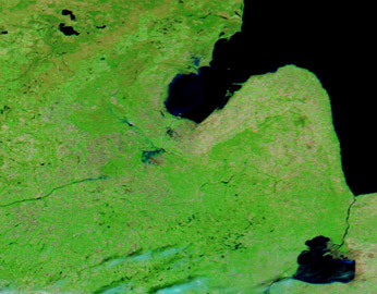
While a single image can illustrate flooding clearly, it can be even more informative to compare pre- and post-flood images. Thanks to the NASA Worldview App, this is easily accomplished. A roll-over image showing Terra MODIS images of this area acquired on May 20 and May 13 can be seen
here.
The NASA Worldview app provides a satellite's perspective of the planet as it looks today and as it has in the past through daily satellite images. Worldview is part of NASA’s Earth Observing System Data and Information System. EOSDIS makes the agency's large repository of data accessible and freely available to the public.
Image Facts
Satellite:
Aqua
Date Acquired: 5/20/2020
Resolutions:
1km (56.2 KB), 500m (136.8 KB), 250m (172.6 KB)
Bands Used: 1,4,3
Image Credit:
MODIS Land Rapid Response Team, NASA GSFC
On May 17, 2020, heavy rain began pouring over central Michigan and, after two days, it provoked significant flooding in Midland County. Local media reported that rushing waters downed trees and damaged roadways, homes and businesses, including damage to the City of Midland. The accumulating rainfall also led to catastrophic dam failures that swelled rivers and streams and inundated several nearby communities. The governor ordered more than 10,000 residents of Edenville and Sanford to evacuate.
The National Weather Service reported record rainfall where more than 4 inches (10 centimeters) fell across parts of Midland in 48 hours. The Edenville Dam then collapsed on the evening of May 19, sending floodwaters south across the landscape. About an hour later, water spilled over the Sanford Dam and further flooded the Tittabawassee River and the surrounding area.
On May 20, the Tittabawassee River reached a height just over 35 feet (11 meters)—about four feet higher than levels in the devastating 1986 floods. The governor has declared a state of emergency. The initial estimate of damage to buildings from the failure of the Edenville Dam at 5,745 parcels with a total building value of $878,974,848.
On May 20, 2020, the Moderate Resolution Imaging Spectroradiometer (MODIS) on board NASA’s Terra satellite acquired a false-color image highlighting the flooding in Midland County, Michigan.
This type of image, using bands 7,2,1, combines infrared and visible light in order to highlight features not as easily visualized in true-color images, such as flood waters. Vegetation appears bright green while deep water, as in Lake Huron’s Saginaw Bay, looks inky-blue. Relatively shallow floodwaters appear lighter blue. Midland City sits near the center of the image, close to the swollen Tittabawassee River. Both the Sanford and Edenville Dams sit to the northwest of Midland City, each area marked by flooding.
While a single image can illustrate flooding clearly, it can be even more informative to compare pre- and post-flood images. Thanks to the NASA Worldview App, this is easily accomplished. A roll-over image showing Terra MODIS images of this area acquired on May 20 and May 13 can be seen here.
The NASA Worldview app provides a satellite's perspective of the planet as it looks today and as it has in the past through daily satellite images. Worldview is part of NASA’s Earth Observing System Data and Information System. EOSDIS makes the agency's large repository of data accessible and freely available to the public.
Image Facts
Satellite:
Aqua
Date Acquired: 5/20/2020
Resolutions:
1km (56.2 KB), 500m (136.8 KB), 250m (172.6 KB)
Bands Used: 1,4,3
Image Credit:
MODIS Land Rapid Response Team, NASA GSFC
