
Images


July 31, 2020 - Flooding in Bangladesh
 Tweet
Tweet
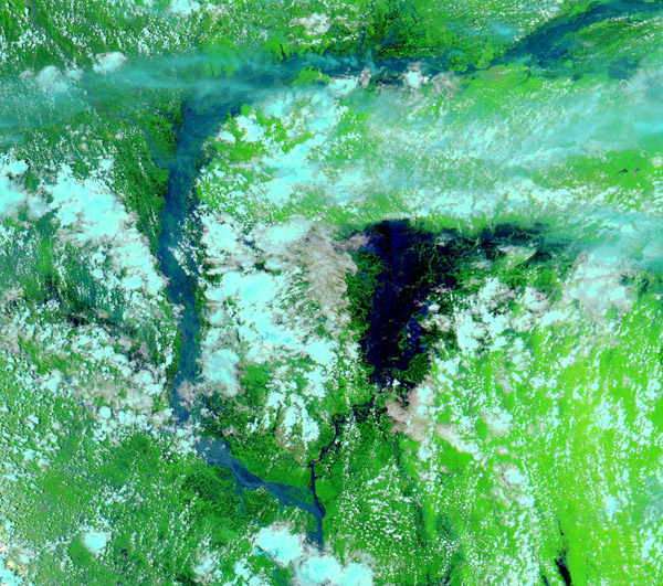
Extremely heavy rains accompanied Asian’s 2020 summer monsoon, bringing severe flooding to Bangladesh by late July. According to ReliefWeb, as of 28 July, 4.7 million people are affected and 984,819 houses inundated, with about 24 percent of the entire country flooded. About 56,000 people have been displaced with about 1,086 flood shelters operational. Over 1,900 schools have been damaged. In addition, more than 150,000 hectares of paddy fields were damaged, along with thousands of latrines and tube wells. Evacuation, sheltering, response, and recovery are more difficult in light of the COVID-19 pandemic, as social distancing is difficult in shelter situations and availability of adequate handwashing facilities hard to find in damaged areas.
On July 25, 2020, the Moderate Resolution Imaging Spectroradiometer (MODIS) on board NASA’s Aqua satellite acquired a false-color image of extensive flooding in Bangladesh.
This type of false color image, created using a combination of infrared and visible light, is particularly helpful to distinguish floods from surrounding landscape. Water appears very dark blue while vegetation on the ground is colored an electric green. Cloud may appear white or, if they are high, cold clouds contain ice crystals and will appear light turquoise.
It is very clear in this one image that most of the major rivers of Bangladesh have overflowed their banks, especially the Brahmaputra which has become exceptionally broad. The extent of the flooding becomes even clearer when compared with an image taken before the flooding. Thanks the NASA Worldview app, we can easily compare this image with one from the MODIS instrument on Aqua acquired on June 7 of the exact same area. That roll-over comparison can be viewed here.
Image Facts
Satellite:
Aqua
Date Acquired: 7/25/2020
Resolutions:
1km (171.9 KB), 500m (489.8 KB), 250m (754.6 KB)
Bands Used: 7,2,1
Image Credit:
MODIS Land Rapid Response Team, NASA GSFC
