
Images


September 22, 2020 - Flooding in Pakistan
 Tweet
Tweet
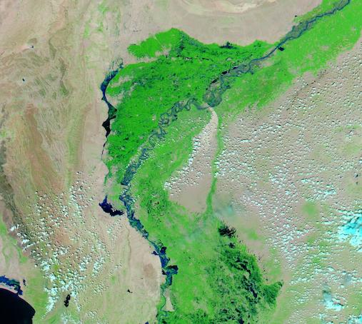
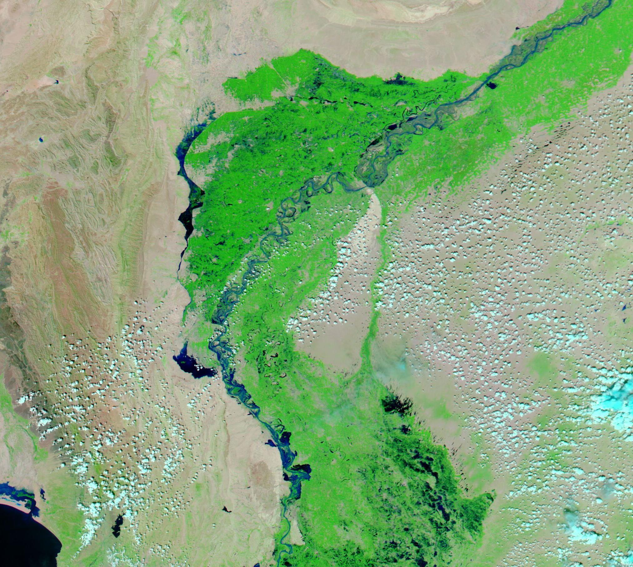
Torrential monsoonal rains brought devastating flooding to Pakistan in August and September 2020. According to media reports, by August 9 three days of monsoonal rains had killed almost 50 people across the country and had damaged over 100 homes. On August 29, Reliefweb reported that the city of Karachi received the heaviest rain in a single day ever recorded in its history when 231 mm (9 inches) of rain fell in just 12 hours. That city received 484 mm (19 in) of rain during August 2020—the highest monthly rainfall on record for the last 90 years.
Pulses of severe rain have continued through late September, resulting in widespread, devastating flooding.
Pakistan’s National Disaster Management Authority has published a monsoon damage report covering June 15 – September 21. Preliminary assessments tally damage to 13 roads, 10 bridges, 20 shops, 3 hotels, 5 masjid (mosques), and 217,848 houses this season. 400 deaths and 392 injuries have been counted. As of September 21, 196 relief camps were operation in the province of Sindh and were housing more than 23,600 people. More than 11,000 people have been evacuated, along with 299 people rescued by 10 boats in District Dadu by Armed Forces and District Administration. Fortunately, dry weather is forecast for the next several days.
On September 20, 2020, the Moderate Resolution Imaging Spectroradiometer (MODIS) on board NASA’s Aqua satellite acquired a false-color image of flooding in Pakistan. This type of false-color image uses infrared and visible light (MODIS bands 7,2,1) to help differentiate water from vegetation or soil. Vegetation appears bright green, open soil appears tan, and water appears blue or inky-black. Clouds often appear tinged with electric blue. In this image, the twisted Indus River appears quite wide and water can be seen over the entire green flood plains. In some areas, especially at the edges of the flood plains, copious deep, dark water is easily visible.
While a single image captures the flooding on a given date, when assessing the extent of damage and/or change it is often helpful to be able to compare two different dates. Thanks to the NASA Worldview app, a roll-over comparison of two images of the same scene, one captured on August 3 (before the record-setting rains fell) and this one, captured on September 20, can be seen
here.
The NASA Worldview app provides a satellite's perspective of the planet as it looks today and as it has in the past through daily satellite images. Worldview is part of NASA’s Earth Observing System Data and Information System. EOSDIS makes the agency's large repository of data accessible and freely available to the public.
Image Facts
Satellite:
Aqua
Date Acquired: 9/20/2020
Resolutions:
1km (55.5 KB), 500m (201.4 KB), 250m (627.4 KB)
Bands Used: 7,2,1
Image Credit:
MODIS Land Rapid Response Team, NASA GSFC
Torrential monsoonal rains brought devastating flooding to Pakistan in August and September 2020. According to media reports, by August 9 three days of monsoonal rains had killed almost 50 people across the country and had damaged over 100 homes. On August 29, Reliefweb reported that the city of Karachi received the heaviest rain in a single day ever recorded in its history when 231 mm (9 inches) of rain fell in just 12 hours. That city received 484 mm (19 in) of rain during August 2020—the highest monthly rainfall on record for the last 90 years. Pulses of severe rain have continued through late September, resulting in widespread, devastating flooding.
Pakistan’s National Disaster Management Authority has published a monsoon damage report covering June 15 – September 21. Preliminary assessments tally damage to 13 roads, 10 bridges, 20 shops, 3 hotels, 5 masjid (mosques), and 217,848 houses this season. 400 deaths and 392 injuries have been counted. As of September 21, 196 relief camps were operation in the province of Sindh and were housing more than 23,600 people. More than 11,000 people have been evacuated, along with 299 people rescued by 10 boats in District Dadu by Armed Forces and District Administration. Fortunately, dry weather is forecast for the next several days.
On September 20, 2020, the Moderate Resolution Imaging Spectroradiometer (MODIS) on board NASA’s Aqua satellite acquired a false-color image of flooding in Pakistan. This type of false-color image uses infrared and visible light (MODIS bands 7,2,1) to help differentiate water from vegetation or soil. Vegetation appears bright green, open soil appears tan, and water appears blue or inky-black. Clouds often appear tinged with electric blue. In this image, the twisted Indus River appears quite wide and water can be seen over the entire green flood plains. In some areas, especially at the edges of the flood plains, copious deep, dark water is easily visible.
While a single image captures the flooding on a given date, when assessing the extent of damage and/or change it is often helpful to be able to compare two different dates. Thanks to the NASA Worldview app, a roll-over comparison of two images of the same scene, one captured on August 3 (before the record-setting rains fell) and this one, captured on September 20, can be seen here.
The NASA Worldview app provides a satellite's perspective of the planet as it looks today and as it has in the past through daily satellite images. Worldview is part of NASA’s Earth Observing System Data and Information System. EOSDIS makes the agency's large repository of data accessible and freely available to the public.
Image Facts
Satellite:
Aqua
Date Acquired: 9/20/2020
Resolutions:
1km (55.5 KB), 500m (201.4 KB), 250m (627.4 KB)
Bands Used: 7,2,1
Image Credit:
MODIS Land Rapid Response Team, NASA GSFC
