
Images


September 28, 2020 - Appalachian Mountains
 Tweet
Tweet
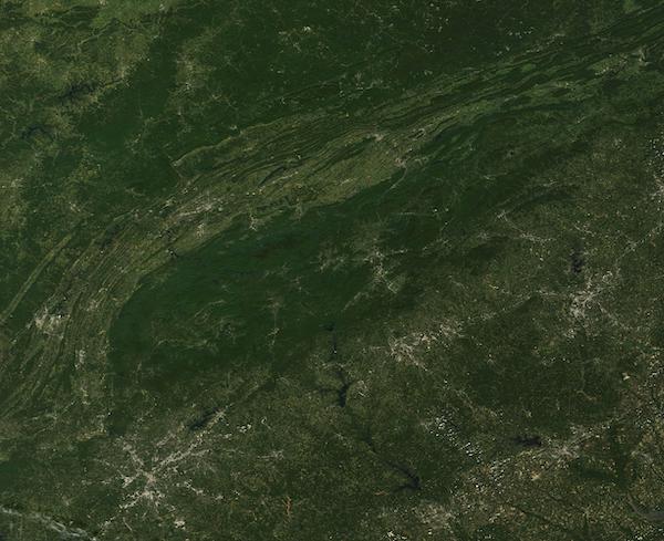
On September 21, 2020, the Moderate Resolution Imaging Spectroradiometer (MODIS) acquired a true-color image of the closing of summer over the Appalachian Mountains.
The broad arc of the ridge-and-valley structure of the Appalachian Mountains curves from the southwest to the northeast, stretching approximately 1,500 miles (2,400 km) from the state of Alabama, USA to Newfoundland, Canada. Although a relatively low mountain chain, the Appalachians are one of the oldest mount chains in the world. The rocks that form these ridges are estimated to be 300 to 540 million years old.
This image captures only a small part of the southern part of the Appalachians as they sweep through the states of Alabama, Georgia, South Carolina, Tennessee, and North Carolina. The deep greens primarily mark forests of deciduous trees intermingled with spruce and fir, which are abundant in the lower elevations and foothills, especially in the eastern section of the Appalachians, which is also known as the Blue Ridge Mountains. The highest peaks rise above the timberline, where tall trees are replaced by shorter, sparser vegetation.
Gray pixels mark the handiwork of humans – roads and cities. The large city of Atlanta, Georgia sits near the southern border of the image, expanding from the center much like a spider web. Moving to the northeast, the city of Greenville, South Carolina is visible. Asheville, North Carolina can be seen north and slightly west of Greenville.
Image Facts
Satellite:
Terra
Date Acquired: 9/21/2020
Resolutions:
1km (50.1 KB), 500m (202.8 KB), 250m (675.7 KB)
Bands Used: 1,4,3
Image Credit:
MODIS Land Rapid Response Team, NASA GSFC
