
Images


October 18, 2020 - Cameron Peak Fire
 Tweet
Tweet
On October 15, 2020, after making a strong run to the east, the Cameron Peak Fire became the largest fire in Colorado’s history, having burned 167,153 acres. By the evening of October 17, the fire had continued to expand, leaving 187,537 acres charred. According to Inciweb Incident Information System, fire officials are expecting extreme fire behavior and rapid spread rates are anticipated to continue through October 17 due to winds that may reach 70 mph (112 km/h) and fuels that are exceptionally dry due to prolonged drought.
1,330 personnel that are actively working the fire have increased the perimeter containment to 57 percent as of late on October 17. Structure containment will continue to be the primary focus as the fire expands towards several populated areas. Two hundred additional structural engines have been ordered and there are orders for additional personnel. Structure triage assessments have been completed in the Fall River corridor, Rocky Mountain National Park, Estes Park, Estes Valley, Glen Haven and Storm Mountain areas and surrounding communities.
The Larimer County Sheriff’s Office with Cameron Peak Fire officials have ordered Mandatory Evacuations for Pinewood Reservoir to Flatiron Reservoir as well as County Road 29 to the west side of County Road 27 north of Highway 34. Residents are advised to leave immediately. Voluntary evacuations for County Road 27 to the Devils Backbone north of Highway 34 are in place and they are also in place for Highway 34 from Soul Shine Road west to Mall Road. Residents there are encouraged to exit the area and to move livestock and pets out of the area and prepare for mandatory evacuations. US 34 Westbound/Eastbound 8 miles west of Loveland to Estes Park (Mile marker 83-64 is closed for emergency operations due to the wildfire.
The Cameron Fire ignited on August 15 just 15 miles southwest of Red Feather Lake, Colorado. Full containment is expected to be achieved on November 8. The previous largest fire in Colorado’s history was the Pine Gulch Fire, which burned 139,007 acres before it was fully contained in late September 2020. The cause of the Cameron Fire is currently under investigation.
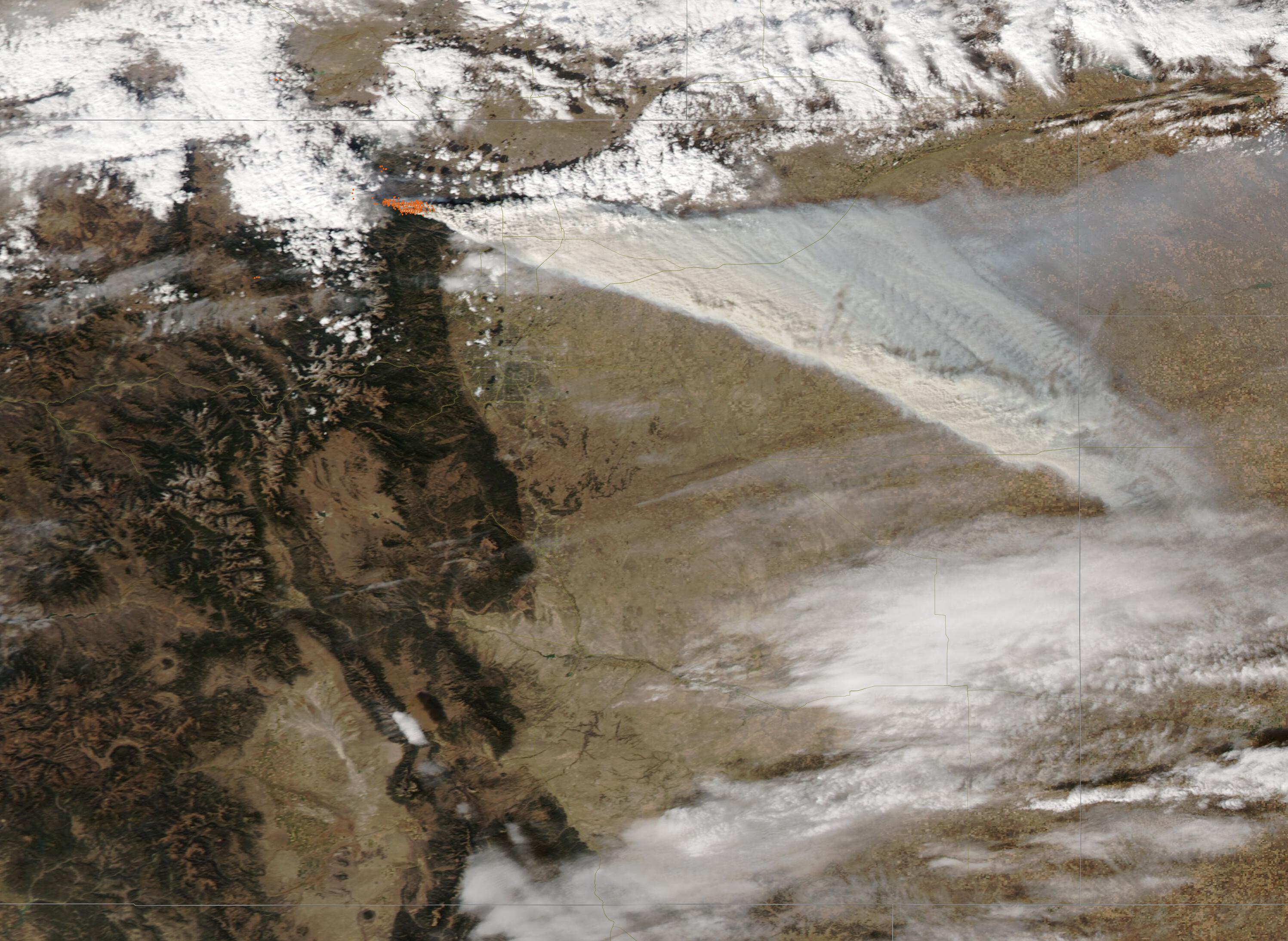
The Moderate Resolution Imaging Spectroradiometer (MODIS) on board NASA’s Aqua satellite acquired a true-color image of the Cameron Fire on October 14. Each red “hot spot” marks an area where temperatures are high, indicating actively burning fire. Copious smoke rises from the large area of active burn and blows to the east and southeast. Fort Collins, Colorado sits underneath the thick smoke and is obscured from view. Roughly half of the plume can be seen in this image. The entire plume stretched more than 450 mi (740 km) eastward, reaching an area south of Lincoln, Nebraska.
Image Facts
Satellite:
Aqua
Date Acquired: 10/14/2020
Resolutions:
1km (79.2 KB), 500m (262.1 KB), 250m (742.8 KB)
Bands Used: 1,4,3
Image Credit:
MODIS Land Rapid Response Team, NASA GSFC
On October 15, 2020, after making a strong run to the east, the Cameron Peak Fire became the largest fire in Colorado’s history, having burned 167,153 acres. By the evening of October 17, the fire had continued to expand, leaving 187,537 acres charred. According to Inciweb Incident Information System, fire officials are expecting extreme fire behavior and rapid spread rates are anticipated to continue through October 17 due to winds that may reach 70 mph (112 km/h) and fuels that are exceptionally dry due to prolonged drought.
1,330 personnel that are actively working the fire have increased the perimeter containment to 57 percent as of late on October 17. Structure containment will continue to be the primary focus as the fire expands towards several populated areas. Two hundred additional structural engines have been ordered and there are orders for additional personnel. Structure triage assessments have been completed in the Fall River corridor, Rocky Mountain National Park, Estes Park, Estes Valley, Glen Haven and Storm Mountain areas and surrounding communities.
The Larimer County Sheriff’s Office with Cameron Peak Fire officials have ordered Mandatory Evacuations for Pinewood Reservoir to Flatiron Reservoir as well as County Road 29 to the west side of County Road 27 north of Highway 34. Residents are advised to leave immediately. Voluntary evacuations for County Road 27 to the Devils Backbone north of Highway 34 are in place and they are also in place for Highway 34 from Soul Shine Road west to Mall Road. Residents there are encouraged to exit the area and to move livestock and pets out of the area and prepare for mandatory evacuations. US 34 Westbound/Eastbound 8 miles west of Loveland to Estes Park (Mile marker 83-64 is closed for emergency operations due to the wildfire.
The Cameron Fire ignited on August 15 just 15 miles southwest of Red Feather Lake, Colorado. Full containment is expected to be achieved on November 8. The previous largest fire in Colorado’s history was the Pine Gulch Fire, which burned 139,007 acres before it was fully contained in late September 2020. The cause of the Cameron Fire is currently under investigation.
The Moderate Resolution Imaging Spectroradiometer (MODIS) on board NASA’s Aqua satellite acquired a true-color image of the Cameron Fire on October 14. Each red “hot spot” marks an area where temperatures are high, indicating actively burning fire. Copious smoke rises from the large area of active burn and blows to the east and southeast. Fort Collins, Colorado sits underneath the thick smoke and is obscured from view. Roughly half of the plume can be seen in this image. The entire plume stretched more than 450 mi (740 km) eastward, reaching an area south of Lincoln, Nebraska.
Image Facts
Satellite:
Aqua
Date Acquired: 10/14/2020
Resolutions:
1km (79.2 KB), 500m (262.1 KB), 250m (742.8 KB)
Bands Used: 1,4,3
Image Credit:
MODIS Land Rapid Response Team, NASA GSFC
