
Images


December 24, 2020 - Volcanic Activity in Hawaii
 Tweet
Tweet
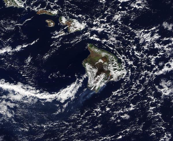
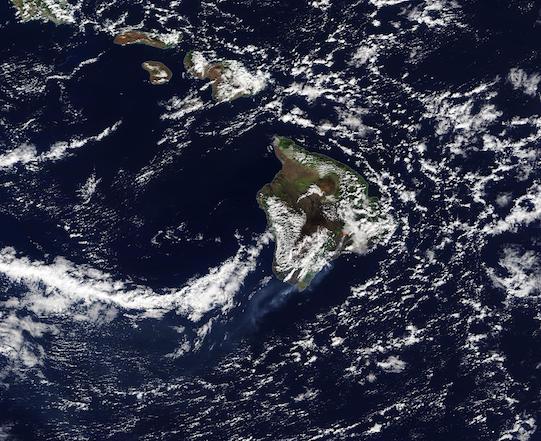
After several weeks of steadily increasing seismic rumbling and ground deformation, Kilauea Volcano began a dramatic eruption on December 20. According to the Hawaiian Volcano Observatory (HVO) observation cameras detected a glow within Halema`uma`u Crater at the summit of Kilauea at 9:30 p.m. Hawaiian Standard Time (2:00 p.m. EST), indicating an eruption had begun. Three fissures subsequently opened in the walls of Halema`uma`u Crater releasing flowing lava. As the lava interacted with the lake at the summit of Kilauea a large plume of steam rose over the volcano. Once the water had boiled away, lava began to pond in the lake. Fountains of lava reached as high as 50 meters (164 feet).
The Moderate Resolution Imaging Spectroradiometer (MODIS) on board NASA’s Terra satellite acquired a true-color image of the eruption on December 21. A red “hot spot” can be seen at the edge of cloud on Kilauea’s summit, marking the location where the thermal bands on the MODIS instrument detected high temperatures caused by lava. A plume of volcanic ash, water vapor, and sulfur dioxide gas streams towards the southwest over the ocean.
As of December 23, the volcano continues active eruption. The HVO estimated that the growing crater lake was 143 m (470 feet) deep with a surface area of 22 ha (54 acres). Sulfur dioxide emission rates are estimated at 30,000 tonnes/day (33,069 US tons/day). Seismicity remains elevated but stable, with a few minor earthquakes and tremors related to vigorous fountaining from the fissures.
Kilauea is the most active and youngest of the Hawaiian shield volcanoes, remaining in near-constant eruption. The volcano had maintained a low level of non-eruptive unrest since the end of the 2018 eruption and summit collapse, which deepened the Halema`uma`u Crater. A lake began to form in the crater in July 2019. Increased rates of uplift were detected by GPS stations beginning in September 2020, and increased earthquake rates began in late November 2020. By December 17, long-period seismic signals beneath the summit increased, suggesting magmatic activity.
According to the HVO, it is unclear how long the current eruption will continue. Kilauea summit eruptions over the past 200 years have lasted from less than a day to more than a decade.
Image Facts
Satellite:
Terra
Date Acquired: 12/21/2020
Resolutions:
1km (78 KB), 500m (252.8 KB), 250m (690.3 KB)
Bands Used: 1,4,3
Image Credit:
MODIS Land Rapid Response Team, NASA GSFC
