
Images


May 4, 2021 - Dust Storm in the Taklimakan Desert
 Tweet
Tweet
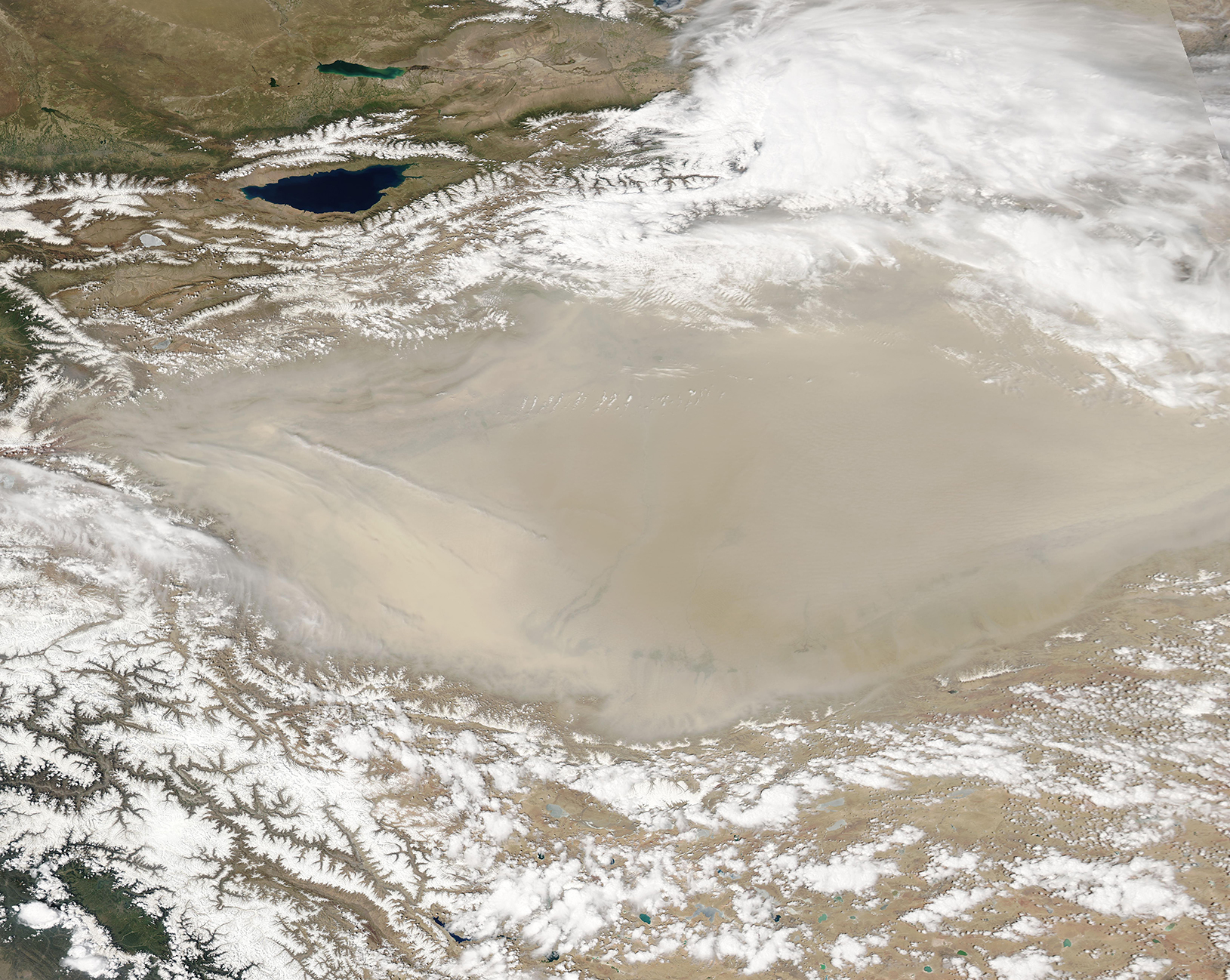
The Taklimakan Desert was surrounded by snow and shrouded by dust in early May 2021. The Moderate Resolution Imaging Spectroradiometer (MODIS) on board NASA’s Aqua satellite acquired a true-color image of the sandy scene on May 1.
One of the driest, most barren places on Earth, the Taklimakan Desert sits in the Tarim Basin in Northwestern China. The Tarim Basin stretches over about 390,000 square miles (1,020,000 square kilometers) and is bordered by the Kunlun Shan mountains to the south and Tian Shan mountains to the north. Parched by the rain shadow of these tall mountain, parts of the desert received no more than 0.4 inches (10 mm) of rain per year.
The extreme aridity means scant vegetation to hold sand in place, so almost 85 percent of the Taklimakan consists of shifting sand dunes, some of which rise to 900 feet (300 meters) tall. The vast stretches of sand, along with little vegetation or moisture, also create perfect conditions for dust storms any time winds blow across the region. Dust storms are a regular occurrence in the Taklimakan Desert, especially in the springtime.
In spring, strong surface winds can sometimes lift dust up to 10 kilometers (6 miles). These particles can then be transported by higher-altitude winds that send them across China and the Pacific. In this image, it appears that dust has raised over the mountains in the northeast and may be mixing with lower levels of cloud.
Image Facts
Satellite:
Aqua
Date Acquired: 5/1/2021
Resolutions:
1km (1.6 MB), 500m (4.4 MB), 250m (3 MB)
Bands Used: 1,4,3
Image Credit:
MODIS Land Rapid Response Team, NASA GSFC
The Taklimakan Desert was surrounded by snow and shrouded by dust in early May 2021. The Moderate Resolution Imaging Spectroradiometer (MODIS) on board NASA’s Aqua satellite acquired a true-color image of the sandy scene on May 1.
One of the driest, most barren places on Earth, the Taklimakan Desert sits in the Tarim Basin in Northwestern China. The Tarim Basin stretches over about 390,000 square miles (1,020,000 square kilometers) and is bordered by the Kunlun Shan mountains to the south and Tian Shan mountains to the north. Parched by the rain shadow of these tall mountain, parts of the desert received no more than 0.4 inches (10 mm) of rain per year.
The extreme aridity means scant vegetation to hold sand in place, so almost 85 percent of the Taklimakan consists of shifting sand dunes, some of which rise to 900 feet (300 meters) tall. The vast stretches of sand, along with little vegetation or moisture, also create perfect conditions for dust storms any time winds blow across the region. Dust storms are a regular occurrence in the Taklimakan Desert, especially in the springtime. In spring, strong surface winds can sometimes lift dust up to 10 kilometers (6 miles). These particles can then be transported by higher-altitude winds that send them across China and the Pacific. In this image, it appears that dust has raised over the mountains in the northeast and may be mixing with lower levels of cloud.
Image Facts
Satellite:
Aqua
Date Acquired: 5/1/2021
Resolutions:
1km (1.6 MB), 500m (4.4 MB), 250m (3 MB)
Bands Used: 1,4,3
Image Credit:
MODIS Land Rapid Response Team, NASA GSFC
