
Images


May 16, 2021 - Color off the Coast of Australia
 Tweet
Tweet
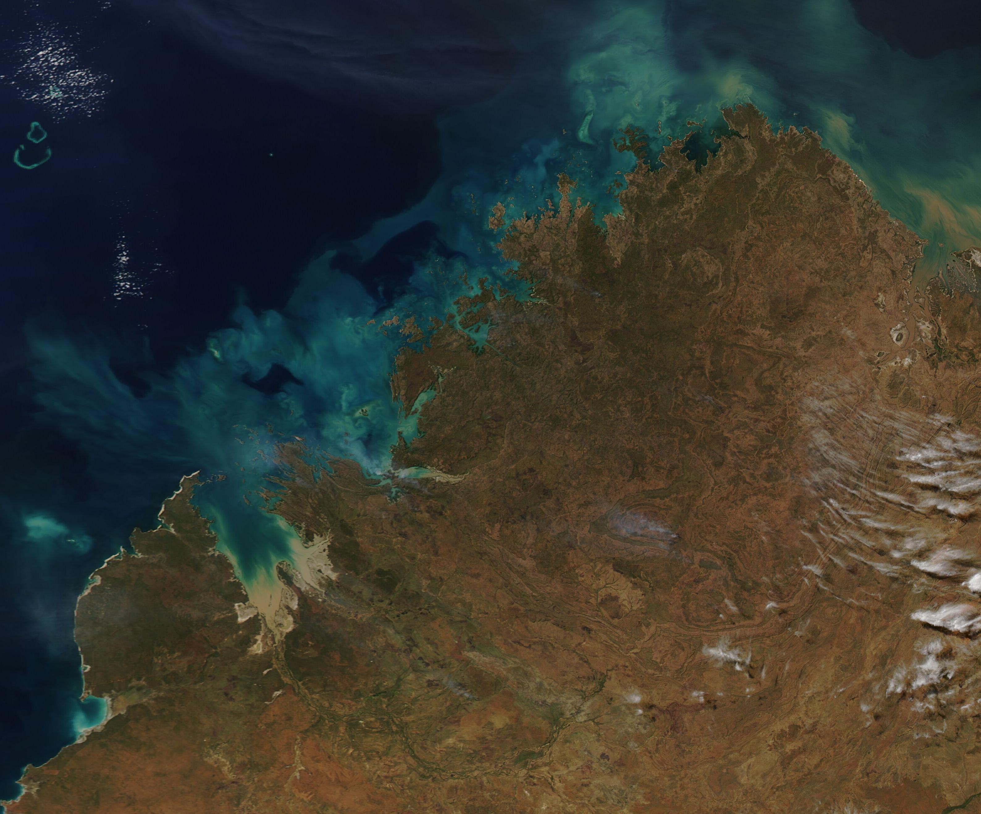
A swirling halo of blue surrounded the coastline of northwestern and northern Australia in mid-May 2021. This gorgeous true-color image was acquired by the Moderate Resolution Imaging Spectroradiometer (MODIS) on board NASA’s Aqua satellite on May 13.
The rugged landscape of Australia’s northern section of Northern Territory makes up roughly the eastern two-thirds of the image, while the northern tip of Western Australia sits in the west. Both regions are colored in bold rust tones, tans and washed with green. In contrast to the rich Earth-tones found inland, stunning shades of blue, turquoise, greens, and tan hug the shoreline. These jewel-toned colors are swept into the deep blue waters of the Indian Ocean by strong currents found just offshore.
Some of the coastal color comes from sediment. One such location is marked by the muddy-brown stain in the King Sound along the southwestern coastline of Western Australian (in this image). The dirt-colored smudge in the water is caused by mud stirred up by the strong tides in shallow Sound. It is also from sediment carried into the Sound by the Fitzroy, one of Australia’s largest rivers.
When sediment floats near the surface, it appears mud-colored; however, as it sinks the reflective properties change, so sunken sediment appears green or blue from space. This change in color can be seen in King Sound, both at the edge of the sediment plume where the color changes from tan to green and further from shore, where the water of the Sound takes on a turquoise tint.
While some of the color surrounding the Australian coast may come from sediment, most of the shining stain most likely comes from large blooms of phytoplankton. These floating, microscopic, plant-like organisms carry pigment that, when massed together in large “blooms”, can easily be seen from space. For the most part, phytoplankton float near the surface of the ocean and float wherever currents take them. Because of this, phytoplankton can sometimes be used to reveal the flow of currents in the ocean.
Image Facts
Satellite:
Aqua
Date Acquired: 5/13/2021
Resolutions:
1km (471 KB), 500m (1.2 MB), 250m (679.4 KB)
Bands Used: 1,4,3
Image Credit:
MODIS Land Rapid Response Team, NASA GSFC
