
Images


May 19, 2021 - The Mackinac Strait
 Tweet
Tweet
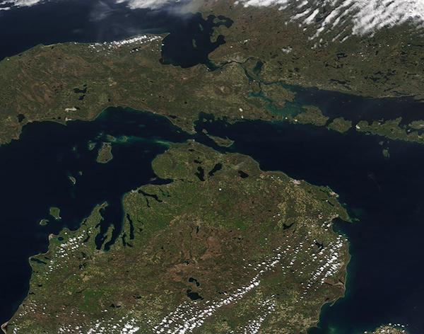
Thousands of years ago, during the Wisconsin Ice Age, much of North America found itself buried under a vast sheet of ice which was as much as two miles (3.2 km) thick in some areas. While the continents were roughly the same size and shape as they were now, the landscape was being ground and shaped into valleys and mountains under the weight of the shifting ice.
Eventually, the melting glaciers stopped grinding forward and began to retreat, slowly melting and filling basins with water. As the Laurentide ice sheet retreated northward, a massive lake formed over lands belonging to modern-day Canada and United States. Over time – lots of time – the slow lifting of the bedrock as it was freed from the weight of the ice sheet began to change the shorelines and Lake Superior, Lake Michigan, and Lake Huron emerged. About 3,000 years ago these lakes attained their present shape. Because of their positively glacial start, the North American Great Lakes are unique among the world’s large lakes in that their basins are linked together and form one continuous drainage basin. Together, they constitute the greatest freshwater system on Earth, covering an area larger than Texas and about half the size of Alaska. Starting in Lake Superior, the water flows out the lake’s southeastern tip down the St. Marys River into Lakes Michigan and Huron.
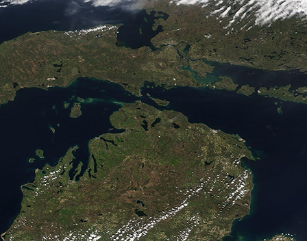
On May 17, 2021, the Moderate Resolution Imaging Spectroradiometer (MODIS) on board NASA’s Aqua satellite acquired a true-color image nearly-centered on the Straits of Mackinac, a stretch of water five miles wide that separates Michigan’s lower and upper peninsulas. The strait connects Lakes Michigan (left) and Huron (right). Lake Superior, which connects to Lake Huron through the St. Mary’s River can be seen in the northwest (upper left).
The gray smudges seen along the St. Mary’s River marks the twin cities of Sault Sainte Marie, Ontario, Canada (north) and Sault Sainte Marie, Michigan, USA (south). The boundary between Canada and the United States divides Lake Superior, St. Mary’s River, and Lake Huron.
Image Facts
Satellite:
Aqua
Date Acquired: 5/17/2021
Resolutions:
1km (169.7 KB), 500m (477.6 KB), 250m (1.3 MB)
Bands Used: 1,4,3
Image Credit:
MODIS Land Rapid Response Team, NASA GSFC
Thousands of years ago, during the Wisconsin Ice Age, much of North America found itself buried under a vast sheet of ice which was as much as two miles (3.2 km) thick in some areas. While the continents were roughly the same size and shape as they were now, the landscape was being ground and shaped into valleys and mountains under the weight of the shifting ice.
Eventually, the melting glaciers stopped grinding forward and began to retreat, slowly melting and filling basins with water. As the Laurentide ice sheet retreated northward, a massive lake formed over lands belonging to modern-day Canada and United States. Over time – lots of time – the slow lifting of the bedrock as it was freed from the weight of the ice sheet began to change the shorelines and Lake Superior, Lake Michigan, and Lake Huron emerged. About 3,000 years ago these lakes attained their present shape. Because of their positively glacial start, the North American Great Lakes are unique among the world’s large lakes in that their basins are linked together and form one continuous drainage basin. Together, they constitute the greatest freshwater system on Earth, covering an area larger than Texas and about half the size of Alaska. Starting in Lake Superior, the water flows out the lake’s southeastern tip down the St. Marys River into Lakes Michigan and Huron.
On May 17, 2021, the Moderate Resolution Imaging Spectroradiometer (MODIS) on board NASA’s Aqua satellite acquired a true-color image nearly-centered on the Straits of Mackinac, a stretch of water five miles wide that separates Michigan’s lower and upper peninsulas. The strait connects Lakes Michigan (left) and Huron (right). Lake Superior, which connects to Lake Huron through the St. Mary’s River can be seen in the northwest (upper left).
The gray smudges seen along the St. Mary’s River marks the twin cities of Sault Sainte Marie, Ontario, Canada (north) and Sault Sainte Marie, Michigan, USA (south). The boundary between Canada and the United States divides Lake Superior, St. Mary’s River, and Lake Huron.
Image Facts
Satellite:
Aqua
Date Acquired: 5/17/2021
Resolutions:
1km (169.7 KB), 500m (477.6 KB), 250m (1.3 MB)
Bands Used: 1,4,3
Image Credit:
MODIS Land Rapid Response Team, NASA GSFC
