Images
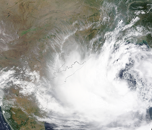
May 25, 2021 - Tropical Cyclone Yaas approaching India
Tweet
On May 24, 2021, the Moderate Resolution Imaging Spectroradiometer (MODIS) on board NASA’s Terra satellite acquired a true-color image of Tropical Cyclone Yaas spinning in the Bay of Bengal heading towards landfall as a Very Severe Cyclonic Storm. That day, the India Meteorological Department (IMD) stated the storm was expected to intensify further and would be likely to cross north Odisha, West Bengal coasts between Paradip and Sagar islands around noon local time (2:30 a.m. EDT) on May 26.
At 11:00 p.m. EDT on May 25 (8:30 a.m. India Standard Time), The Joint Typhoon Warning Center (JTWC) reported that Tropical Cyclone Yaas was carrying maximum sustained winds of 60 mph (111 km/h). The storm was located about 305 miles (490 km) south of Kolkata, India and was tracking to the northwest. The JTWC anticipates landfall close to Bhitarkanika National Park with wind speeds of about 81 mph (131 km/h). Bhitarkanika National Park is located in Kendrapara District in eastern India and is the second-largest mangrove system in India, and home to endangered saltwater crocodiles.
As the storm approached on May 25, local news media reported that a boat had capsized in Odisha, with 8 people missing Approximately 3 million people may be affected by this storm, with about 1 million may “observe high impact” according to the Global Disaster and Alert Coordination System (GDACS). While the winds will be most severe in eastern India, heavy rains are expected to strike India, Bangladesh, and Sri Lanka.
Image Facts
Satellite:
Terra
Date Acquired: 5/24/2021
Resolutions:
1km (2.4 MB), 500m (6.6 MB), 250m (4.2 MB)
Bands Used: 1,4,3
Image Credit:
MODIS Land Rapid Response Team, NASA GSFC


