Images
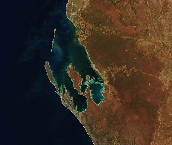
June 21, 2021 - Shark Bay
Tweet
Long before William Dampier—an English explorer, pirate, and natural historian—first set eyes on the rich waters and bays he dubbed “Shark Bay”, the wondrously biodiverse area was well known to local indigenous peoples. According to the Shark Bay World Heritage Site webpage, the local Malanga Aboriginal peoples called this area Gutharraguda, a word meaning “two waters”—and an apt description of two protected bays formed by a pair of nearly parallel peninsulas found off the far western Australian coastline.
Sitting about 820 km (510 miles) north of Perth, Shark Bay looks a bit like the letter “W” when viewed from space. Edel Land Peninsula and Dirk Hartog Island lay together along the western reaches, with steep limestone cliffs that rise steeply along the Indian Ocean on the peninsula and sandy dunes on islands. Perron Peninsula sits in the center and houses tidal flats in the west and rusty red-sand dunes in the east. Hamelin Pool is found Between Perron Peninsula and the mainland coast.
Shark Bay has become famous for its biodiversity, especially the massive underwater meadows of seagrass which stretch across the eastern shore and include 12 of the world’s 60 known seagrass species. The Wooramel seagrass bank is the largest on Earth, spanning 1,000 square kilometers along 130 km along Shark Bay’s eastern coastline. Probably the most unusual and fascinating forms of life here are stromatolites—layered rocks that are created when microbes trap particles and create sediments. The stromatolites found here are some of the most diverse in the world.
Image Facts
Satellite:
Aqua
Date Acquired: 6/18/2021
Resolutions:
1km (137.5 KB), 500m (353.7 KB), 250m (198 KB)
Bands Used: 1,4,3
Image Credit:
MODIS Land Rapid Response Team, NASA GSFC


