
Images


August 24, 2021 - Ice retreat in the Northwest Passage
 Tweet
Tweet
The idea of winding through a patchwork of Canadian islands to sail from the Atlantic Ocean to the Pacific Ocean has stirred exploration dreams for many hundreds of years. As early as the second century A.D., the ancient Greeks drew a navigable waterway at the top of the world on their maps. While the frozen and nearly impenetrable passage stirred the hearts of countless explorers, it wasn’t until 1906 that a European explorer, Roald Amundsen, successfully navigated the icy Northwest Passage. He and his crew of six managed the feat in three years on his 70- x 20-foot square-sterned sloop, Gjøa.
Today, traversing the Northwest Passage is not unusual and, as climate warms, commercial traffic and use by tourist vessels is becoming more common, as ice along the route becomes increasingly sparse in summer. The passage, which spans 900 miles from the North Atlantic north of Canada’s Baffin Island in the east to the Beaufort Sea north of the U.S. state of Alaska in the west, lies entirely within the Arctic Circle.
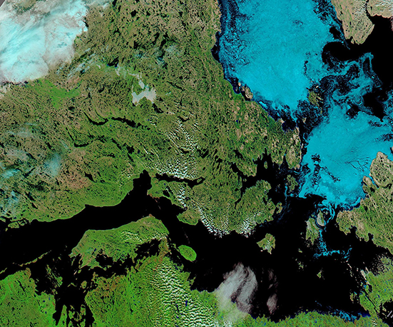
On August 22, 2021, the Moderate Resolution Imaging Spectroradiometer (MODIS) on board NASA’s Aqua satellite acquired a false-color image of ice retreating in the Northwest Passage. This type of image uses a combination short-wave infrared, near-infrared, and visible light (MODIS bands 7-2-1) to help separate snow and ice from cloud. All three appear white in a true-color image, but here ice and snow are electric blue, cloud appears white, vegetation is green, open land (soil and rock) looks tan, and deep water appears inky-blue. When clouds are very cold and contain ice crystals, they also take on a light blue tint.
On this day, a coating of Arctic sea ice (bright blue) remains floating on the Arctic waters between Victoria Island (west) and King William Island (east). In contrast, the more southerly waters, such as Victoria Strait, are ice-free. A few small clouds float over the open waters of the Northwest Passage.
Image Facts
Satellite:
Aqua
Date Acquired: 8/22/2021
Resolutions:
1km (436.4 KB), 500m (1.4 MB), 250m (3.9 MB)
Bands Used: 7,2,1
Image Credit:
MODIS Land Rapid Response Team, NASA GSFC
The idea of winding through a patchwork of Canadian islands to sail from the Atlantic Ocean to the Pacific Ocean has stirred exploration dreams for many hundreds of years. As early as the second century A.D., the ancient Greeks drew a navigable waterway at the top of the world on their maps. While the frozen and nearly impenetrable passage stirred the hearts of countless explorers, it wasn’t until 1906 that a European explorer, Roald Amundsen, successfully navigated the icy Northwest Passage. He and his crew of six managed the feat in three years on his 70- x 20-foot square-sterned sloop, Gjøa.
Today, traversing the Northwest Passage is not unusual and, as climate warms, commercial traffic and use by tourist vessels is becoming more common, as ice along the route becomes increasingly sparse in summer. The passage, which spans 900 miles from the North Atlantic north of Canada’s Baffin Island in the east to the Beaufort Sea north of the U.S. state of Alaska in the west, lies entirely within the Arctic Circle.
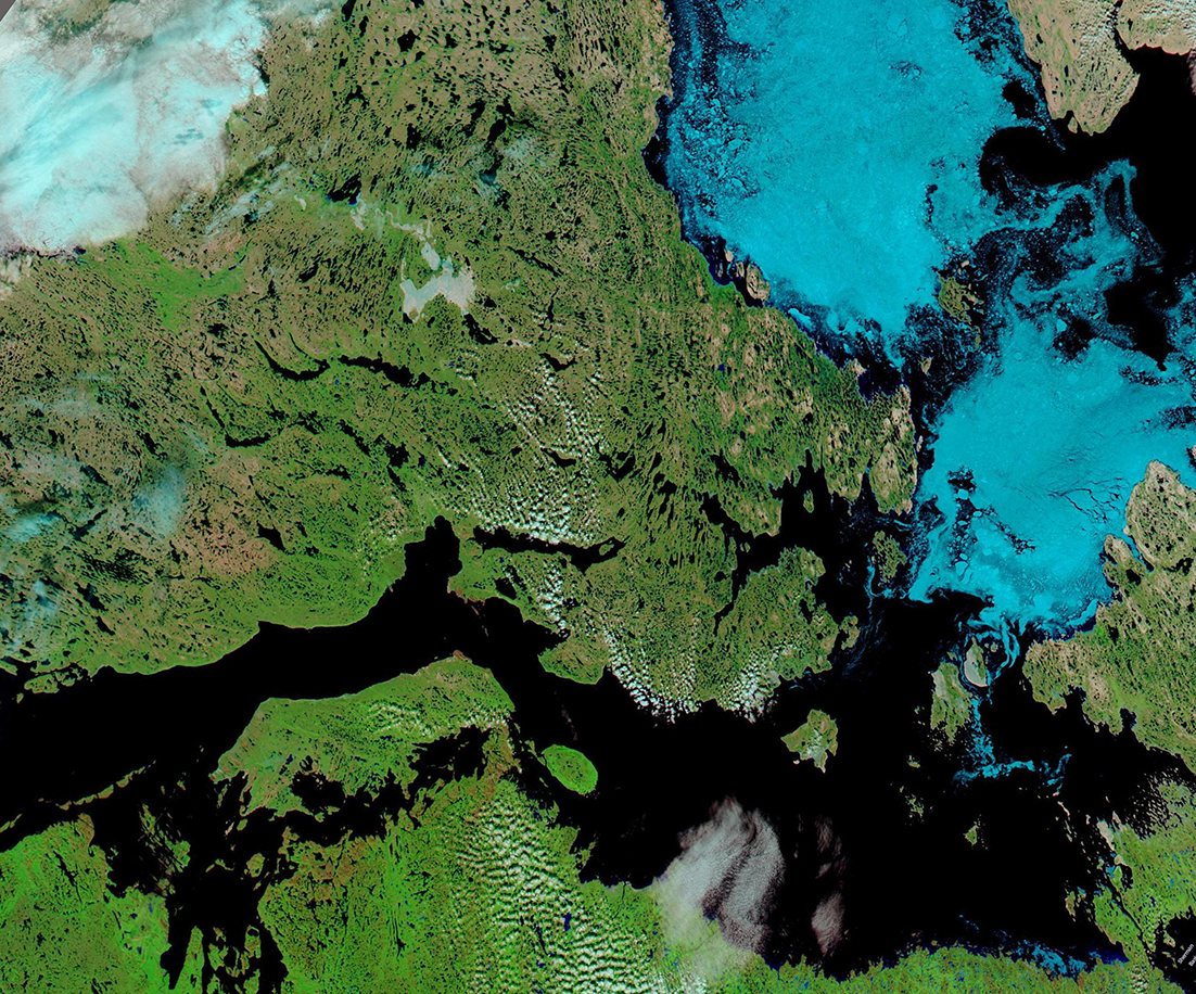
On August 22, 2021, the Moderate Resolution Imaging Spectroradiometer (MODIS) on board NASA’s Aqua satellite acquired a false-color image of ice retreating in the Northwest Passage. This type of image uses a combination short-wave infrared, near-infrared, and visible light (MODIS bands 7-2-1) to help separate snow and ice from cloud. All three appear white in a true-color image, but here ice and snow are electric blue, cloud appears white, vegetation is green, open land (soil and rock) looks tan, and deep water appears inky-blue. When clouds are very cold and contain ice crystals, they also take on a light blue tint.
On this day, a coating of Arctic sea ice (bright blue) remains floating on the Arctic waters between Victoria Island (west) and King William Island (east). In contrast, the more southerly waters, such as Victoria Strait, are ice-free. A few small clouds float over the open waters of the Northwest Passage.
Image Facts
Satellite:
Aqua
Date Acquired: 8/22/2021
Resolutions:
1km (436.4 KB), 500m (1.4 MB), 250m (3.9 MB)
Bands Used: 7,2,1
Image Credit:
MODIS Land Rapid Response Team, NASA GSFC
